Photo Mug > Europe > United Kingdom > Scotland > Maps
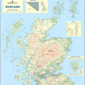
Photo Mug : Map Of The British Isles, Circa. 1760. From "Atlas De Toutes Les Parties Connues Du Globe Terrestre "By Cartographer Rigobert Bonne. Published Geneva Circa. 1760


![]()
Home Decor from Design Pics
Map Of The British Isles, Circa. 1760. From "Atlas De Toutes Les Parties Connues Du Globe Terrestre "By Cartographer Rigobert Bonne. Published Geneva Circa. 1760
Map Of The British Isles, Circa.1760. From " Atlas De Toutes Les Parties Connues Du Globe Terrestre " By Cartographer Rigobert Bonne. Published Geneva Circa. 1760
Design Pics offers Distinctively Different Imagery representing over 1,500 contributors
Media ID 18186469
© Ken Welsh / Design Pics
Cartography Geography Isles Mapmaking Plate Scotland Wales
Large Photo Mug (15 oz)
Add a touch of history to your daily routine with our Media Storehouse Photo Mug featuring a vintage map of the British Isles. This beautiful design is taken from Rigobert Bonne's "Atlas De Toutes Les Parties Connues Du Globe Terrestre," published in Geneva around 1760. The intricate details of the map, showcasing the British Isles during that era, are sure to captivate and inspire. Each mug is expertly printed with high-quality images, ensuring your coffee or tea remains the only thing that heats up. Perfect for history enthusiasts, map collectors, or anyone who appreciates the beauty of the past, this mug makes a unique and thoughtful gift. Embrace the rich history of cartography with every sip.
Elevate your coffee or tea experience with our premium white ceramic mug. Its wide, comfortable handle makes drinking easy, and you can rely on it to be both microwave and dishwasher safe. Sold in single units, preview may show both sides of the same mug so you can see how the picture wraps around.
Elevate your coffee or tea experience with our premium white ceramic mug. Its wide, comfortable handle makes drinking easy, and you can rely on it to be both microwave and dishwasher safe. Sold in single units, preview may show both sides of the same mug so you can see how the picture wraps around.
These are individually made so all sizes are approximate
FEATURES IN THESE COLLECTIONS
> Europe
> Republic of Ireland
> Maps
> Europe
> United Kingdom
> England
> Maps
> Europe
> United Kingdom
> Scotland
> Maps
> Europe
> United Kingdom
> Wales
> Maps
> Europe
> United Kingdom
> Wales
> Posters
> Europe
> United Kingdom
> Wales
> Related Images
> Maps and Charts
> Related Images
> Maps and Charts
> Wales
EDITORS COMMENTS
This stunning print showcases a historical treasure - the Map of the British Isles, circa 1760. Created by renowned cartographer Rigobert Bonne and published in Geneva during the same period, this map is a testament to the artistry and precision of early mapmaking. The intricate details and vibrant colors bring this piece to life, allowing viewers to explore the geography of England, Scotland, Wales, and Ireland from centuries ago. The carefully engraved lines depict coastlines, rivers, mountains, and cities with remarkable accuracy. As we gaze upon this vertical plate illustration, we are transported back in time to an era when exploration was at its peak. This map serves as a window into history - a snapshot of how people perceived their world over two centuries ago. Beyond its aesthetic appeal lies its educational value. Students of geography can delve into the past as they study changes in borders or discover forgotten towns that have since faded away. History enthusiasts can trace trade routes or imagine what life was like for those living on these lands long ago. Ken Welsh's expert photography captures every minute detail with clarity and precision. Whether displayed in homes or classrooms alike, this print is sure to captivate all who lay eyes upon it – reminding us of our connection to both our ancestors' journeys and the ever-changing landscapes that shape our present-day reality.
MADE IN THE USA
Safe Shipping with 30 Day Money Back Guarantee
FREE PERSONALISATION*
We are proud to offer a range of customisation features including Personalised Captions, Color Filters and Picture Zoom Tools
SECURE PAYMENTS
We happily accept a wide range of payment options so you can pay for the things you need in the way that is most convenient for you
* Options may vary by product and licensing agreement. Zoomed Pictures can be adjusted in the Cart.