Mouse Mat > Europe > Belgium > Posters
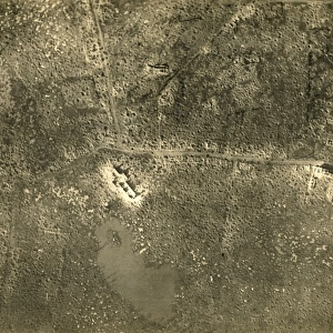
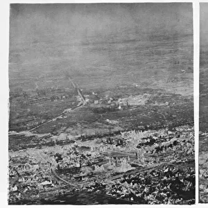
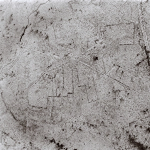
Mouse Mat : Aerial photograph of Polygon Wood, Belgium, WW1


![]()
Home Decor from Mary Evans Picture Library
Aerial photograph of Polygon Wood, Belgium, WW1
Aerial photograph (British) of Polygon Wood (Polygoneveld, or Bois de Polygone), near Ypres, Belgium, during the First World War. A small conflict took place here on 26-27 September 1917 during the second phase of the Battle of Passchendaele. Date: 11 September 1917
Mary Evans Picture Library makes available wonderful images created for people to enjoy over the centuries
Media ID 7181835
© Mary Evans Picture Library 2015 - https://copyrighthub.org/s0/hub1/creation/maryevans/MaryEvansPictureID/10528475
Belgian Bois Conflict Flanders Passchendaele Polygon Reconnaissance Ypres War Time Ww 1
Mouse Pad
Standard Size Mouse Pad 7.75" x 9..25". High density Neoprene w linen surface. Easy to clean, stain resistant finish. Rounded corners.
Archive quality photographic print in a durable wipe clean mouse mat with non slip backing. Works with all computer mice
Estimated Image Size (if not cropped) is 23.7cm x 18.5cm (9.3" x 7.3")
Estimated Product Size is 23.7cm x 20.2cm (9.3" x 8")
These are individually made so all sizes are approximate
Artwork printed orientated as per the preview above, with landscape (horizontal) orientation to match the source image.
EDITORS COMMENTS
This aerial photograph, taken on September 11, 1917, provides a hauntingly beautiful yet poignant view of Polygon Wood, near Ypres, Belgium, during the First World War. The image captures the tranquil scene of the woodland area, now devoid of the chaos and destruction that once defined this place. However, this serene image belies the intense conflict that took place here just a few days prior. On September 26-27, 1917, during the second phase of the Battle of Passchendaele, a small but significant battle unfolded in Polygon Wood. British forces, under the command of Lieutenant General Plumer, launched an attack on the German lines in an effort to gain ground and push towards Passchendaele. The battle was marked by heavy rain, which turned the ground into a quagmire, making progress slow and arduous for both sides. Despite the challenges, the British forces were ultimately successful in their mission, capturing the German lines and securing a strategic position. The victory came at a great cost, with thousands of soldiers from both sides losing their lives in the muddy, bloody battlefield. This aerial photograph, taken by British reconnaissance, offers a unique perspective of the battlefield, revealing the intricate patterns of trenches and shell craters that scarred the land. It serves as a reminder of the brutal reality of war and the sacrifices made by soldiers during this pivotal moment in history. Polygon Wood, now a peaceful and picturesque woodland area, stands as a testament to the resilience of nature and the enduring legacy of the First World War.
MADE IN THE USA
Safe Shipping with 30 Day Money Back Guarantee
FREE PERSONALISATION*
We are proud to offer a range of customisation features including Personalised Captions, Color Filters and Picture Zoom Tools
SECURE PAYMENTS
We happily accept a wide range of payment options so you can pay for the things you need in the way that is most convenient for you
* Options may vary by product and licensing agreement. Zoomed Pictures can be adjusted in the Cart.