Home > Europe > Belgium > Lakes
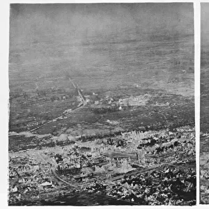
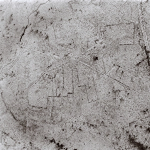
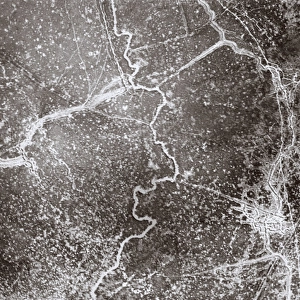
Aerial photograph of Zonnebeke, Belgium, WW1

![]()
Wall Art and Photo Gifts from Mary Evans Picture Library
Aerial photograph of Zonnebeke, Belgium, WW1
Aerial photograph (British) of the area around Zonnebeke, including Zonnebeke Lake and Church, Belgium, on the western front during the First World War. It was destroyed during the Battle of Passchendaele. Date: 25 September 1917
Mary Evans Picture Library makes available wonderful images created for people to enjoy over the centuries
Media ID 7183287
© Mary Evans Picture Library 2015 - https://copyrighthub.org/s0/hub1/creation/maryevans/MaryEvansPictureID/10528452
Area Belgian Damage Damaged Destroyed Flanders Reconnaissance Roads Territory Ypres War Time Ww 1 Zonnebeke
FEATURES IN THESE COLLECTIONS
> Aerial Photography
> Belgium
> Historic
> Battles
> Related Images
> Religious Art
> Religious Architecture
> Churches and Cathedrals
EDITORS COMMENTS
This aerial photograph, taken on September 25, 1917, provides a haunting view of the devastated landscape around Zonnebeke, Belgium, during the First World War. The image captures the western front, with the area around Zonnebeke Lake and the town's iconic church clearly visible. The tranquil waters of the lake have been transformed into a muddy expanse, a result of the intense fighting during the Battle of Passchendaele. The church, a historic landmark in the Flanders region, lies in ruins, its once majestic spire now reduced to rubble. The roads and buildings in the surrounding terrain display the scars of war, with craters and destruction evident throughout the area. The Battle of Passchendaele, also known as the Third Battle of Ypres, was one of the costliest battles in World War 1 for the British and Commonwealth forces. The battle raged from July to November 1917, resulting in over 275,000 casualties. This photograph is a poignant reminder of the devastating impact of war on the land and its people. The destruction captured in the image is a testament to the brutal and destructive nature of the conflict that engulfed Europe during this period. The photograph was taken by British reconnaissance forces, providing valuable intelligence for military planning and strategy during the war.
MADE IN THE USA
Safe Shipping with 30 Day Money Back Guarantee
FREE PERSONALISATION*
We are proud to offer a range of customisation features including Personalised Captions, Color Filters and Picture Zoom Tools
SECURE PAYMENTS
We happily accept a wide range of payment options so you can pay for the things you need in the way that is most convenient for you
* Options may vary by product and licensing agreement. Zoomed Pictures can be adjusted in the Cart.