Metal Print > Universal Images Group (UIG) > Art > Painting, Sculpture & Prints > Cartography
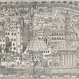
Metal Print : Map of The confines of Siena from Regionum Italiae by Willem Blaeu, engraving


![]()
Metal Prints From Universal Images Group (UIG)
Map of The confines of Siena from Regionum Italiae by Willem Blaeu, engraving
Cartography, Italy, 17th century. The confines of Siena. From Regionum Italiae by Willem Blaeu. Engraving
Universal Images Group (UIG) manages distribution for many leading specialist agencies worldwide
Media ID 9504477
© DEA / A. DAGLI ORTI
17th Century Aerial View Border Coastline Guidance Human Settlement Nautical Vessel Navigational Equipment Ship Siena Text Tuscany Willem Blaeu Non Urban Scene
16"x20" (51x41cm) Metal Print
Discover the rich history of Italy with our stunning Media Storehouse Metal Prints. This particular piece features an exquisite 17th-century map of Siena, as depicted in Willem Blaeu's "Regionum Italiae." The intricate engraving from Universal Images Group showcases the confines of this historic Italian city in remarkable detail. Our Metal Prints are not just beautiful works of art, but also a testament to the craftsmanship of the past. Bring this piece home and add a touch of history and sophistication to your decor. Each Metal Print is printed on high-quality metal sheets using a sublimation process, ensuring vibrant colors and long-lasting durability. Order yours today and let the story of Siena unfold in your home or office.
Made with durable metal and luxurious printing techniques, our metal photo prints go beyond traditional canvases, adding a cool, modern touch to your space. Wall mount on back. Eco-friendly 100% post-consumer recycled ChromaLuxe aluminum surface. The thickness of the print is 0.045". Featuring a Scratch-resistant surface and Rounded corners. Backing hangers are attached to the back of the print and float the print 1/2-inch off the wall when hung, the choice of hanger may vary depending on size and International orders will come with Float Mount hangers only. Finished with a brilliant white high gloss surface for unsurpassed detail and vibrance. Printed using Dye-Sublimation and for best care we recommend a non-ammonia glass cleaner, water, or isopropyl (rubbing) alcohol to prevent harming the print surface. We recommend using a clean, lint-free cloth to wipe off the print. The ultra-hard surface is scratch-resistant, waterproof and weatherproof. Avoid direct sunlight exposure.
Made with durable metal and luxurious printing techniques, metal prints bring images to life and add a modern touch to any space
Estimated Image Size (if not cropped) is 50.8cm x 40.6cm (20" x 16")
Estimated Product Size is 51.4cm x 41.2cm (20.2" x 16.2")
These are individually made so all sizes are approximate
Artwork printed orientated as per the preview above, with landscape (horizontal) orientation to match the source image.
EDITORS COMMENTS
This print showcases a remarkable piece of cartography from the 17th century. The Map of The confines of Siena, crafted by the talented Willem Blaeu, takes us on a journey through the enchanting landscapes of Tuscany, Italy. With intricate details and precise topography, this engraving offers a glimpse into history and serves as a valuable navigational tool. The aerial view depicted in this horizontal artwork allows us to marvel at the natural beauty that surrounds Siena. From lush green hills to meandering rivers and even glimpses of the sparkling sea, every element is meticulously captured with artistic finesse. As we explore this map further, our eyes are drawn to human settlements along the coastline and beyond - evidence of past civilizations that once thrived in these lands. With its rich historical context and expert craftsmanship, this print not only serves as an exquisite piece of art but also provides invaluable guidance for travelers seeking to navigate through Tuscany's diverse terrain. It reminds us of how maps have been instrumental in shaping our understanding of geography throughout time. Whether you're an admirer of fine art or a curious traveler yearning for knowledge about ancient landscapes, this Map of The confines of Siena will transport you back in time while igniting your sense of adventure.
MADE IN THE USA
Safe Shipping with 30 Day Money Back Guarantee
FREE PERSONALISATION*
We are proud to offer a range of customisation features including Personalised Captions, Color Filters and Picture Zoom Tools
SECURE PAYMENTS
We happily accept a wide range of payment options so you can pay for the things you need in the way that is most convenient for you
* Options may vary by product and licensing agreement. Zoomed Pictures can be adjusted in the Basket.