Jigsaw Puzzle > Universal Images Group (UIG) > Art > Painting, Sculpture & Prints > Cartography
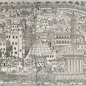
Jigsaw Puzzle : Map of The confines of Siena from Regionum Italiae by Willem Blaeu, engraving


![]()
Jigsaw Puzzles From Universal Images Group (UIG)
Map of The confines of Siena from Regionum Italiae by Willem Blaeu, engraving
Cartography, Italy, 17th century. The confines of Siena. From Regionum Italiae by Willem Blaeu. Engraving
Universal Images Group (UIG) manages distribution for many leading specialist agencies worldwide
Media ID 9504477
© DEA / A. DAGLI ORTI
17th Century Aerial View Border Coastline Guidance Human Settlement Nautical Vessel Navigational Equipment Ship Siena Text Tuscany Willem Blaeu Non Urban Scene
Jigsaw Puzzle (520 Pieces)
Step back in time with our exquisite Jigsaw Puzzle from Media Storehouse, featuring a captivating 17th-century map of Siena from the renowned atlas 'Regionum Italiae' by Willem Blaeu. This intricately detailed engraving invites you on a journey through the rich history of Italy, as you piece together the borders of Siena. A perfect addition to any home or office, this challenging puzzle is not only a fun activity but also a beautiful way to decorate and inspire.
Made in the USA, 520-piece puzzles measure 16" x 20" (40.6 x 50.8 cm). Every puzzle is meticulously printed on glossy photo paper, which has a strong 1.33 mm thickness. Delivered in a black storage cardboard box, these puzzles are both stylish and practical. (Note: puzzles contain small parts and are not suitable for children under 3 years of age.)
Jigsaw Puzzles are an ideal gift for any occasion
Estimated Product Size is 50.8cm x 40.5cm (20" x 15.9")
These are individually made so all sizes are approximate
Artwork printed orientated as per the preview above, with landscape (horizontal) or portrait (vertical) orientation to match the source image.
EDITORS COMMENTS
This print showcases a remarkable piece of cartography from the 17th century. The Map of The confines of Siena, crafted by the talented Willem Blaeu, takes us on a journey through the enchanting landscapes of Tuscany, Italy. With intricate details and precise topography, this engraving offers a glimpse into history and serves as a valuable navigational tool. The aerial view depicted in this horizontal artwork allows us to marvel at the natural beauty that surrounds Siena. From lush green hills to meandering rivers and even glimpses of the sparkling sea, every element is meticulously captured with artistic finesse. As we explore this map further, our eyes are drawn to human settlements along the coastline and beyond - evidence of past civilizations that once thrived in these lands. With its rich historical context and expert craftsmanship, this print not only serves as an exquisite piece of art but also provides invaluable guidance for travelers seeking to navigate through Tuscany's diverse terrain. It reminds us of how maps have been instrumental in shaping our understanding of geography throughout time. Whether you're an admirer of fine art or a curious traveler yearning for knowledge about ancient landscapes, this Map of The confines of Siena will transport you back in time while igniting your sense of adventure.
MADE IN THE USA
Safe Shipping with 30 Day Money Back Guarantee
FREE PERSONALISATION*
We are proud to offer a range of customisation features including Personalised Captions, Color Filters and Picture Zoom Tools
SECURE PAYMENTS
We happily accept a wide range of payment options so you can pay for the things you need in the way that is most convenient for you
* Options may vary by product and licensing agreement. Zoomed Pictures can be adjusted in the Basket.