Metal Print > Europe > United Kingdom > England > London > Museums > London Canal Museum
Metal Print : First geological map of Britain, 1815 C016 / 5680


![]()
Metal Prints from Science Photo Library
First geological map of Britain, 1815 C016 / 5680
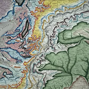
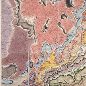
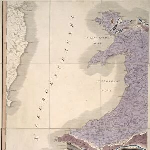
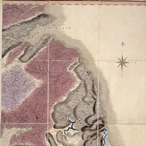
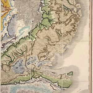
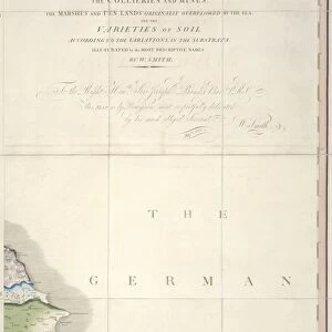
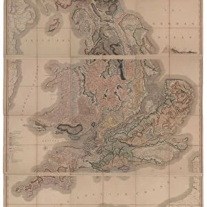
First geological map of Britain showing a detail of the north west coast. This map was published in 1815 by British geologist William Smith (1769-1839). It shows rock layers (strata) in England and Wales and part of Scotland (key at lower left). Smiths work as a canal surveyor allowed him to study geology. He discovered that geological strata could be reliably identified at different places on the basis of the fossils they contained. Smith also proposed the principle of superposition, that if a strata overlays another then it was laid down at a later time. He is considered the father of English geology
Science Photo Library features Science and Medical images including photos and illustrations
Media ID 9206561
© NATURAL HISTORY MUSEUM, LONDON/SCIENCE PHOTO LIBRARY
1815 Cartography Coast Coastal Country Early Earth Science Geological Great Britain Irish Sea North West Pioneering Region Scotland Scottish Strata Stratigraphy Stratum Superposition Welsh William Smith Isle Of Man
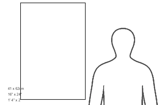
16"x24" (61x41cm) Metal Print
Discover the rich history of geology with our stunning Metal Prints featuring the First Geological Map of Britain, 1815 C016 / 5680 by the Natural History Museum, London/Science Photo Library. This iconic map, published by renowned British geologist William Smith in 1815, is a testament to the early developments in the field of geology. The intricate details of the northwest coast come alive in vibrant colors on our high-quality metal prints, making this a unique and captivating addition to any home or office space. Bring a piece of scientific history into your world with our Metal Prints.
Made with durable metal and luxurious printing techniques, our metal photo prints go beyond traditional canvases, adding a cool, modern touch to your space. Wall mount on back. Eco-friendly 100% post-consumer recycled ChromaLuxe aluminum surface. The thickness of the print is 0.045". Featuring a Scratch-resistant surface and Rounded corners. Backing hangers are attached to the back of the print and float the print 1/2-inch off the wall when hung, the choice of hanger may vary depending on size and International orders will come with Float Mount hangers only. Finished with a brilliant white high gloss surface for unsurpassed detail and vibrance. Printed using Dye-Sublimation and for best care we recommend a non-ammonia glass cleaner, water, or isopropyl (rubbing) alcohol to prevent harming the print surface. We recommend using a clean, lint-free cloth to wipe off the print. The ultra-hard surface is scratch-resistant, waterproof and weatherproof. Avoid direct sunlight exposure.
Made with durable metal and luxurious printing techniques, metal prints bring images to life and add a modern touch to any space
Estimated Product Size is 41.2cm x 61.5cm (16.2" x 24.2")
These are individually made so all sizes are approximate
Artwork printed orientated as per the preview above, with portrait (vertical) orientation to match the source image.
FEATURES IN THESE COLLECTIONS
> Arts
> Artists
> I
> William Ireland
> Europe
> Republic of Ireland
> Maps
> Europe
> United Kingdom
> England
> London
> Museums
> British Library
> Europe
> United Kingdom
> England
> London
> Museums
> British Museum
> Europe
> United Kingdom
> England
> London
> Museums
> London Canal Museum
> Europe
> United Kingdom
> England
> London
> Museums
> Natural History Museum
> Europe
> United Kingdom
> England
> London
> Museums
> Science Museum
> Europe
> United Kingdom
> England
> London
> Sights
> British Museum
> Europe
> United Kingdom
> England
> London
> Sights
> London Canal Museum
> Europe
> United Kingdom
> England
> London
> Towns
> Lower Place
EDITORS COMMENTS
This print showcases the first geological map of Britain, a groundbreaking work published in 1815 by British geologist William Smith. The map offers an intricate detail of the north west coast, encompassing England and Wales as well as part of Scotland. With its key located at the lower left corner, this historical artifact provides a comprehensive depiction of rock layers (strata) found across the region. William Smith's remarkable contribution to geology stemmed from his career as a canal surveyor, which allowed him to closely study the Earth's composition. Through meticulous research, he made a significant discovery that fossils within different strata could be used to reliably identify geological formations in various locations. Moreover, Smith proposed the principle of superposition: if one stratum overlaid another, it was deposited at a later time. Regarded as the father of English geology, Smith revolutionized our understanding of Earth's history and paved the way for further scientific advancements in stratigraphy and cartography. This pioneering artwork not only illustrates his profound impact on earth science but also highlights his role in shaping our knowledge about Britain's geographical landscape during the early 19th century. Displayed proudly by NATURAL HISTORY MUSEUM LONDON/SCIENCE PHOTO LIBRARY, this print serves as a testament to both Smith's ingenuity and Britain's rich geological heritage.
MADE IN THE USA
Safe Shipping with 30 Day Money Back Guarantee
FREE PERSONALISATION*
We are proud to offer a range of customisation features including Personalised Captions, Color Filters and Picture Zoom Tools
SECURE PAYMENTS
We happily accept a wide range of payment options so you can pay for the things you need in the way that is most convenient for you
* Options may vary by product and licensing agreement. Zoomed Pictures can be adjusted in the Cart.