Metal Print > Arts > Artists > O > Oceanic Oceanic
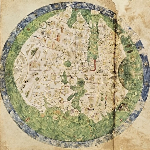
Metal Print : World Map by Rumold Mercator (1512-1594)
")

![]()
Metal Prints From Mary Evans Picture Library
World Map by Rumold Mercator (1512-1594)
Orbis Terrae Compendiosa Descriptio. World map, 1587. Detail of America. By Rumold Mercator (1545-1599)
Mary Evans Picture Library makes available wonderful images created for people to enjoy over the centuries
Media ID 14330266
© Thaliastock / Mary Evans
1587 Atlantic Cartographic Cartography Compendiosa Continent Continents Descriptio Flanders Geography Latin Letters Mercator Netherlands Oceania Orbis Pacific Terrae Planisphere Rumold
16"x20" (51x41cm) Metal Print
Discover the captivating allure of history with our Media Storehouse Metal Prints featuring the intricately detailed World Map by Rumold Mercator. Dating back to 1587, this exquisite map, sourced from Mary Evans Prints Online, showcases the world as it was known during the Renaissance era. The intricate lines and vibrant colors are brought to life on high-quality metal, creating a stunning and unique piece of art for your home or office. Each Metal Print is expertly crafted to ensure the finest detail and vibrant colors, making it a must-have for history enthusiasts and art collectors alike. Experience the rich history of cartography with our Media Storehouse Metal Prints.
Made with durable metal and luxurious printing techniques, our metal photo prints go beyond traditional canvases, adding a cool, modern touch to your space. Wall mount on back. Eco-friendly 100% post-consumer recycled ChromaLuxe aluminum surface. The thickness of the print is 0.045". Featuring a Scratch-resistant surface and Rounded corners. Backing hangers are attached to the back of the print and float the print 1/2-inch off the wall when hung, the choice of hanger may vary depending on size and International orders will come with Float Mount hangers only. Finished with a brilliant white high gloss surface for unsurpassed detail and vibrance. Printed using Dye-Sublimation and for best care we recommend a non-ammonia glass cleaner, water, or isopropyl (rubbing) alcohol to prevent harming the print surface. We recommend using a clean, lint-free cloth to wipe off the print. The ultra-hard surface is scratch-resistant, waterproof and weatherproof. Avoid direct sunlight exposure.
Made with durable metal and luxurious printing techniques, metal prints bring images to life and add a modern touch to any space
Estimated Image Size (if not cropped) is 40.6cm x 50.8cm (16" x 20")
Estimated Product Size is 41.2cm x 51.4cm (16.2" x 20.2")
These are individually made so all sizes are approximate
Artwork printed orientated as per the preview above, with portrait (vertical) orientation to match the source image.
FEATURES IN THESE COLLECTIONS
> Africa
> South Africa
> Maps
> Africa
> South Africa
> Related Images
> Arts
> Artists
> O
> Oceanic Oceanic
> Europe
> Netherlands
> Maps
> Europe
> Netherlands
> Posters
> Europe
> Netherlands
> Related Images
> Maps and Charts
> Early Maps
EDITORS COMMENTS
This detail from the World Map, Orbis Terrae Compendiosa Descriptio, created by the renowned Flemish cartographer Rumold Mercator in 1587, offers a glimpse into the geographic knowledge of the late 16th century. Mercator, a prominent figure in the Age of Discoveries, produced this intricately detailed planisphere during the height of the Netherlands' cartographic golden age. The map showcases the known continents of Europe, Asia, Africa, America, and Oceania, with the Atlantic and Pacific Oceans separating them. Mercator's map is noteworthy for its accurate representation of the coastlines of Europe and Africa, as well as the expanding knowledge of the New World, which is depicted with a more realistic shape than earlier maps. The map's title, Orbis Terrae Compendiosa Descriptio, translates to "Comprehensive Description of the Whole World," reflecting the growing European curiosity and ambition to explore and chart the vast expanses of the globe. Mercator's map is also significant for its use of the Mercator projection, a cylindrical map projection that preserves angles and shapes along meridians, making it ideal for navigational purposes. This stunning detail of the map highlights the Americas, with the Atlantic Ocean to the east and the Pacific Ocean to the west. The map's Latin labels reveal the names of various countries, rivers, and regions, providing a fascinating glimpse into the geographic knowledge of the time. This detail from Rumold Mercator's World Map offers a captivating window into the geographic exploration and discovery of the late 16th century.
MADE IN THE USA
Safe Shipping with 30 Day Money Back Guarantee
FREE PERSONALISATION*
We are proud to offer a range of customisation features including Personalised Captions, Color Filters and Picture Zoom Tools
SECURE PAYMENTS
We happily accept a wide range of payment options so you can pay for the things you need in the way that is most convenient for you
* Options may vary by product and licensing agreement. Zoomed Pictures can be adjusted in the Basket.