Metal Print > Maps and Charts > Willem Janszoon Blaeu
Metal Print : MAP: NEW ENGLAND, 1635. Line engraving of Nova Belgica et Anglia Nova from Willem


![]()
Metal Prints from Granger
MAP: NEW ENGLAND, 1635. Line engraving of Nova Belgica et Anglia Nova from Willem
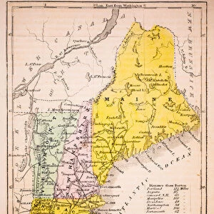
MAP: NEW ENGLAND, 1635.
Line engraving of Nova Belgica et Anglia Nova from Willem Janszoon Blaeus Atlas of 1635, showing the coast of North America from Virginia to the St. Lawrence River
Granger holds millions of images spanning more than 25,000 years of world history, from before the Stone Age to the dawn of the Space Age
Media ID 12321169
1635 Atlas Bear Beaver Blaeu Coast Colony Deer Janszoon New England Portolan Chart Ship United States Village Willem Nova
16"x20" (51x41cm) Metal Print
Discover the rich history of New England in 1635 with our stunning Metal Print of the classic map, "Nova Belgica et Anglia Nova," from the Willem Janszoon Blaeu Atlas. This intricately detailed line engraving showcases the coastline from Virginia to the St. Lawrence River, offering a captivating glimpse into the early exploration of North America. Bring history to life in your home or office with the vibrant colors and durability of our Metal Prints. Each print is made-to-order and coated with a protective finish to ensure long-lasting beauty.
Made with durable metal and luxurious printing techniques, our metal photo prints go beyond traditional canvases, adding a cool, modern touch to your space. Wall mount on back. Eco-friendly 100% post-consumer recycled ChromaLuxe aluminum surface. The thickness of the print is 0.045". Featuring a Scratch-resistant surface and Rounded corners. Backing hangers are attached to the back of the print and float the print 1/2-inch off the wall when hung, the choice of hanger may vary depending on size and International orders will come with Float Mount hangers only. Finished with a brilliant white high gloss surface for unsurpassed detail and vibrance. Printed using Dye-Sublimation and for best care we recommend a non-ammonia glass cleaner, water, or isopropyl (rubbing) alcohol to prevent harming the print surface. We recommend using a clean, lint-free cloth to wipe off the print. The ultra-hard surface is scratch-resistant, waterproof and weatherproof. Avoid direct sunlight exposure.
Made with durable metal and luxurious printing techniques, metal prints bring images to life and add a modern touch to any space
Estimated Image Size (if not cropped) is 50.8cm x 40.6cm (20" x 16")
Estimated Product Size is 51.4cm x 41.2cm (20.2" x 16.2")
These are individually made so all sizes are approximate
Artwork printed orientated as per the preview above, with landscape (horizontal) orientation to match the source image.
FEATURES IN THESE COLLECTIONS
> Granger Art on Demand
> Maps
> Maps and Charts
> Willem Janszoon Blaeu
EDITORS COMMENTS
This print titled "MAP: NEW ENGLAND, 1635" takes us back in time to the early days of American colonization. The line engraving, sourced from Willem Janszoon Blaeus Atlas of 1635, offers a detailed depiction of the North American coast stretching from Virginia to the St. Lawrence River. The image showcases the rugged beauty of this untamed land, with its dense forests and pristine rivers. A ship can be seen sailing along the coastline, symbolizing the arrival of European explorers and settlers seeking new opportunities across the Atlantic. Intriguingly, a diverse array of wildlife is also featured in this map. Majestic bears roam freely through thickets while graceful deer graze peacefully nearby. Beavers busily construct their dams along meandering streams, highlighting their vital role in trade and commerce during that era. A charming village nestled by the shore stands as evidence that human presence has begun to shape this landscape. This settlement represents one among many colonies established by brave pioneers who sought fortune and freedom on these shores. Overall, this historic print not only serves as an educational tool but also evokes a sense of wonder about New England's past. It reminds us how far we have come since those early days when America was still being discovered and shaped into what it is today - a nation built upon exploration, resilience, and diversity.
MADE IN THE USA
Safe Shipping with 30 Day Money Back Guarantee
FREE PERSONALISATION*
We are proud to offer a range of customisation features including Personalised Captions, Color Filters and Picture Zoom Tools
SECURE PAYMENTS
We happily accept a wide range of payment options so you can pay for the things you need in the way that is most convenient for you
* Options may vary by product and licensing agreement. Zoomed Pictures can be adjusted in the Cart.