Metal Print > Arts > Portraits > Animal portraiture > Fine art photography
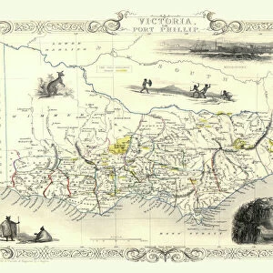
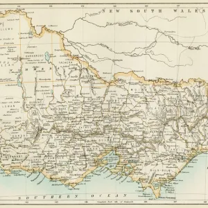
Metal Print : Antique map of Victoria or Port Phillip in Australia with vignettes


![]()
Metal Prints from Fine Art Storehouse
Antique map of Victoria or Port Phillip in Australia with vignettes
Unleash your creativity and transform your space into a visual masterpiece!
Hemera Technologies
Media ID 13609507
© Getty Images
Aboriginal Aborigine Australia Border Culture Decoration Decorative Direction Document Fancy Geography Group Of Objects Habitat Indigenous Culture Indigenous Peoples Intricacy Intricate Kangaroo Legend Location Marsupial Native Natives Ornamental Ornate Place Positioning Scenics Nature Small Group Of People Vignette Vignettes Aborigines
16"x20" (51x41cm) Metal Print
Step back in time with our exquisite Media Storehouse Metal Prints featuring an Antique Map of Victoria or Port Phillip in Australia. These stunning works of art transport you to a bygone era with intricate detail and vibrant colors. Each print is enhanced with captivating vignettes by Hemera Technologies from Fine Art Storehouse, adding depth and character to the historical cartography. The sleek, modern metal print material brings out the rich textures and hues of the map, making it a unique and eye-catching addition to any home or office decor. Preserve history in a contemporary way with our Antique Map Metal Prints.
Made with durable metal and luxurious printing techniques, our metal photo prints go beyond traditional canvases, adding a cool, modern touch to your space. Wall mount on back. Eco-friendly 100% post-consumer recycled ChromaLuxe aluminum surface. The thickness of the print is 0.045". Featuring a Scratch-resistant surface and Rounded corners. Backing hangers are attached to the back of the print and float the print 1/2-inch off the wall when hung, the choice of hanger may vary depending on size and International orders will come with Float Mount hangers only. Finished with a brilliant white high gloss surface for unsurpassed detail and vibrance. Printed using Dye-Sublimation and for best care we recommend a non-ammonia glass cleaner, water, or isopropyl (rubbing) alcohol to prevent harming the print surface. We recommend using a clean, lint-free cloth to wipe off the print. The ultra-hard surface is scratch-resistant, waterproof and weatherproof. Avoid direct sunlight exposure.
Made with durable metal and luxurious printing techniques, metal prints bring images to life and add a modern touch to any space
Estimated Image Size (if not cropped) is 50.8cm x 40.6cm (20" x 16")
Estimated Product Size is 51.4cm x 41.2cm (20.2" x 16.2")
These are individually made so all sizes are approximate
Artwork printed orientated as per the preview above, with landscape (horizontal) orientation to match the source image.
FEATURES IN THESE COLLECTIONS
> Fine Art Storehouse
> Map
> Historical Maps
> Animals
> Fishes
> G
> Grouper
> Animals
> Mammals
> Marsupials
> Animals
> Mammals
> Small Mammals
> Arts
> Contemporary art
> Photography
> Nature-inspired artwork
> Arts
> Portraits
> Animal portraiture
> Fine art photography
> Maps and Charts
> Early Maps
> Maps and Charts
> Related Images
> Oceania
> Australia
> Related Images
EDITORS COMMENTS
This antique map of Victoria or Port Phillip in Australia takes us on a journey back to the 19th century. With its intricate details and ornate borders, this archival print showcases the rich history and cultural heritage of the indigenous peoples who once inhabited these lands. The map is adorned with vignettes that offer glimpses into the diverse habitat and scenic beauty of this region. From marsupials like kangaroos to small groups of people engaged in daily activities, each vignette tells a story about the vibrant life that thrived here centuries ago. As we study this vintage piece, we are transported to a time when cartography was both an art form and a scientific endeavor. The key and legend provide valuable insights into the physical geography and positioning of Victoria or Port Phillip. While there are no people depicted directly in this image, their presence can be felt through references to aboriginal culture and indigenous traditions. This serves as a reminder of their deep connection with nature, which is beautifully captured through Hemera Technologies' photography. With its warm color palette and exquisite attention to detail, this antique map invites us to appreciate not only its decorative value but also the historical significance it holds. It stands as a testament to our collective past while offering glimpses into an era long gone by.
MADE IN THE USA
Safe Shipping with 30 Day Money Back Guarantee
FREE PERSONALISATION*
We are proud to offer a range of customisation features including Personalised Captions, Color Filters and Picture Zoom Tools
SECURE PAYMENTS
We happily accept a wide range of payment options so you can pay for the things you need in the way that is most convenient for you
* Options may vary by product and licensing agreement. Zoomed Pictures can be adjusted in the Cart.