Metal Print > Arts > Artists > C > Craig Craig
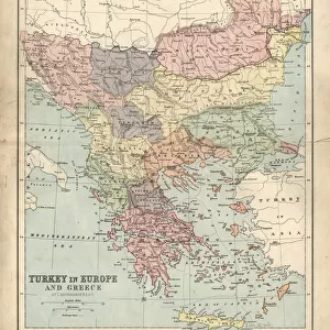
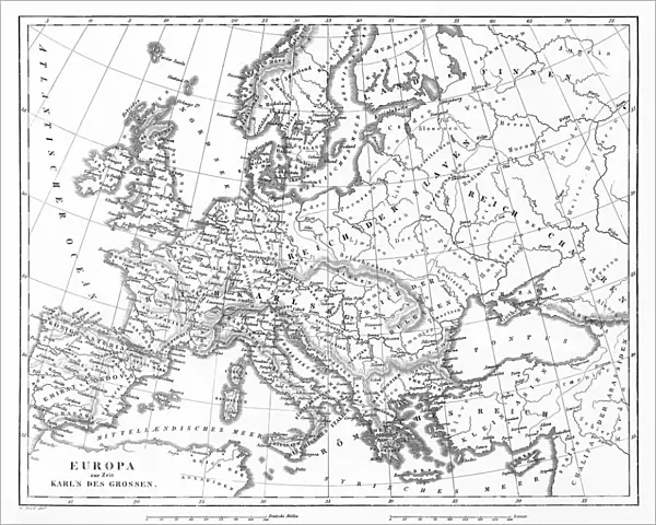
Metal Print : Victorian Map of Europe


![]()
Metal Prints from Fine Art Storehouse
Victorian Map of Europe
Engraved illustrations of Europe in the Time of Charlemagne from Iconographic Encyclopedia of Science, Literature and Art, Published in 1851. Copyright has expired on this artwork. Digitally restored
Unleash your creativity and transform your space into a visual masterpiece!
bauhaus1000
Media ID 13666975
© Craig McCausland
1850 1859 Austria Belgian Culture Belgium British Culture Chart Country Geographic Area Denmark Diagram Drypoint European Culture French Culture German Culture Greece Greek Culture Image Created 1850 1859 Irish Culture Italian Culture Netherlands Northern Ireland Norway Plan Poland Republic Of Ireland Steel Engraving Sweden Swiss Culture Switzerland World Map Drawing Art Product Image Created 19th Century Victorian Style
16"x20" (51x41cm) Metal Print
Discover history like never before with Media Storehouse's Metal Prints. Our high-quality offering showcases this stunning Victorian Map of Europe by bauhaus1000 from the Fine Art Storehouse. This intricately detailed engraving, taken from the Iconographic Encyclopedia of Science, Literature and Art, published in 1851, depicts Europe during the time of Charlemagne. With copyright expired, we're able to bring this historical artwork to life in a new way. Our metal prints are not just beautiful home decor, but a journey through time. Experience the rich history of Europe with every glance at this captivating piece.
Made with durable metal and luxurious printing techniques, our metal photo prints go beyond traditional canvases, adding a cool, modern touch to your space. Wall mount on back. Eco-friendly 100% post-consumer recycled ChromaLuxe aluminum surface. The thickness of the print is 0.045". Featuring a Scratch-resistant surface and Rounded corners. Backing hangers are attached to the back of the print and float the print 1/2-inch off the wall when hung, the choice of hanger may vary depending on size and International orders will come with Float Mount hangers only. Finished with a brilliant white high gloss surface for unsurpassed detail and vibrance. Printed using Dye-Sublimation and for best care we recommend a non-ammonia glass cleaner, water, or isopropyl (rubbing) alcohol to prevent harming the print surface. We recommend using a clean, lint-free cloth to wipe off the print. The ultra-hard surface is scratch-resistant, waterproof and weatherproof. Avoid direct sunlight exposure.
Made with durable metal and luxurious printing techniques, metal prints bring images to life and add a modern touch to any space
Estimated Image Size (if not cropped) is 50.8cm x 40.6cm (20" x 16")
Estimated Product Size is 51.4cm x 41.2cm (20.2" x 16.2")
These are individually made so all sizes are approximate
Artwork printed orientated as per the preview above, with landscape (horizontal) orientation to match the source image.
FEATURES IN THESE COLLECTIONS
> Fine Art Storehouse
> Map
> Denmark Maps
> Fine Art Storehouse
> Map
> Historical Maps
> Fine Art Storehouse
> Map
> Italian Maps
> Arts
> Artists
> C
> Craig Craig
> Arts
> Literature
> Illustration
> Arts
> Literature
> Arts
> Street art graffiti
> Digital art
> Digital paintings
> Europe
> Austria
> Paintings
> Europe
> Austria
> Related Images
> Europe
> Belgium
> Paintings
EDITORS COMMENTS
This print showcases a meticulously engraved Victorian Map of Europe, offering a fascinating glimpse into the continent during the time of Charlemagne. Published in 1851 as part of the Iconographic Encyclopedia of Science, Literature and Art, this artwork has now entered the public domain after its copyright expired. Painstakingly restored digitally, it retains its original charm and intricate details. The map transports us back to the 19th century with its distinct style, reminiscent of woodcut illustrations and paintings from that era. It serves as both a historical document and an artistic masterpiece, capturing European culture at a pivotal moment in history. From Poland to Spain, Italy to Greece, Switzerland to Germany – each country is depicted with precision and care. The engraving beautifully portrays famous landmarks and physical geography across Europe's diverse landscape. As we explore this enchanting image created over 150 years ago using drypoint engraving techniques on steel plates, we are reminded of how travel and tourism have evolved throughout time. This map not only offers geographical insights but also provides glimpses into Victorian society's fascination with exploration. Immerse yourself in this remarkable piece that seamlessly combines artistry with cartography. Let your imagination wander through centuries past as you appreciate the craftsmanship behind this stunning representation of European history.
MADE IN THE USA
Safe Shipping with 30 Day Money Back Guarantee
FREE PERSONALISATION*
We are proud to offer a range of customisation features including Personalised Captions, Color Filters and Picture Zoom Tools
SECURE PAYMENTS
We happily accept a wide range of payment options so you can pay for the things you need in the way that is most convenient for you
* Options may vary by product and licensing agreement. Zoomed Pictures can be adjusted in the Cart.