Metal Print > Classical art
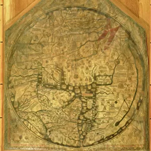
Metal Print : Mappa Mundi, the first printed map of the world, from Etymologiae


![]()
Metal Prints from Fine Art Finder
Mappa Mundi, the first printed map of the world, from Etymologiae
3482941 Mappa Mundi, the first printed map of the world, from Etymologiae by Isidorus Hispalensis, Augsburg: GAonther Zainer, 19 November 1472 (woodcut) by German School, (15th century); 31.1x20.8 cm; Private Collection; (add.info.: ISIDORUS HISPALENSIS (ca 560-636). Etymologiae. [Augsburg:] GAonther Zainer, 19 November 1472.
Chancery 2o (311 x 208 mm). Collation: [14; 210(6+1) 3-1310 148(+- 3; 3+1) 15-2410 258; 2610 2710(9+2)]. 264 leaves. 38 lines, the table in double column. Type: 3:107R. Three full-page woodcuts on 14/5v and 14/6r-v (foredges cropped within image), small woodcut map on 19/7v. Small woodcut mathematical and lunar symbols in text on 6/1r, 2r and 6/8r. 3-, 5- 6- and 7-line initial spaces, printed guide-letters in quires 23-25 only; spaces for Greek words in the text. Initials, capital strokes and part numbers supplied in red. The table with printed word " Finit" as in BMC IB. 5440. (12/6 with marginal repaired tear, 15/5 with two pale stains, 21/3 and 4 with pale marginal dampstain, 27/11 with inner margin renewed, some occasional pale browning at extreme top margin.) Early 18th-century russia gilt, spine gilt, Wodhulls arms in gilt at center of front cover (rebacked preserving original spine panel). Provenance: Michael Wodhull (1740-1816), noted book collector and bibliophile, classical scholar and first English translator of Euripides, who " bought with great judgement, " according to de Ricci (signature and note of purchase of 1 May 1794 from the Hayes sale, purchased for 5s 5d, binding for a cost of 17d) -- Wodhull-Severne sale, 1886, lot 1344 -- Hans Meyer (manuscript ex libris) -- Clifford Rattey (bookplate) -- Acquired from Jacob Zeitlin, 1972.
FIRST EDITION, CONTAINING THE FIRST PRINTED MAP OF THE WORLD.
THE FIRST PRINTED MAP. It is the most rudimentary of T-O maps, a type which originated in the 5th century B.C. and was perpetuated, in a Christianized version, in manuscripts of the Etymologiae from the 8th century. In this basic type the disc of the world is divided into three zones separated by a T-shaped Mediterranean Sea, with Asia uppermost, and Europe and Africa in the two lower sections, the whole circumscribed by the world ocean. Each continent bears the additional name of the son of Noah who was said to have settled it.); Photo eChristies Images; German, out of copyright
Media ID 23296542
© Christie's Images / Bridgeman Images
Cartographic Diagram Disc Early Renaissance Mappa Mundi Mapping Mediterranean Movable Type Oceans Publishing Settlement Stylised Terrestrial Northern Renaissance Zones
16"x20" (51x41cm) Metal Print
Discover the historical significance of the first printed map of the world with our Media Storehouse Metal Prints featuring the intricately detailed Mappa Mundi from Etymologiae by Isidorus Hispalensis. Dating back to 1472, this woodcut masterpiece by the German School showcases a captivating representation of the known world during the Renaissance era. Bring this piece of history into your home or office as a stunning and conversation-starting decorative accent. Our high-quality Metal Prints are known for their vibrant colors, rich textures, and long-lasting durability. Order yours today and join the ranks of those who appreciate the beauty and importance of historical art.
Made with durable metal and luxurious printing techniques, our metal photo prints go beyond traditional canvases, adding a cool, modern touch to your space. Wall mount on back. Eco-friendly 100% post-consumer recycled ChromaLuxe aluminum surface. The thickness of the print is 0.045". Featuring a Scratch-resistant surface and Rounded corners. Backing hangers are attached to the back of the print and float the print 1/2-inch off the wall when hung, the choice of hanger may vary depending on size and International orders will come with Float Mount hangers only. Finished with a brilliant white high gloss surface for unsurpassed detail and vibrance. Printed using Dye-Sublimation and for best care we recommend a non-ammonia glass cleaner, water, or isopropyl (rubbing) alcohol to prevent harming the print surface. We recommend using a clean, lint-free cloth to wipe off the print. The ultra-hard surface is scratch-resistant, waterproof and weatherproof. Avoid direct sunlight exposure.
Made with durable metal and luxurious printing techniques, metal prints bring images to life and add a modern touch to any space
Estimated Image Size (if not cropped) is 40.6cm x 50.8cm (16" x 20")
Estimated Product Size is 41.2cm x 51.4cm (16.2" x 20.2")
These are individually made so all sizes are approximate
Artwork printed orientated as per the preview above, with portrait (vertical) orientation to match the source image.
FEATURES IN THESE COLLECTIONS
> Fine Art Finder
> Artists
> Abraham Drentwett
> Fine Art Finder
> Artists
> German School
> Fine Art Finder
> Maps (celestial & Terrestrial)
> Africa
> Related Images
> Animals
> Mammals
> Brown Bear
> Animals
> Mammals
> Ursidae
> Brown bear
> Animals
> Wild
> Bears
> Brown Bear
> Arts
> Art Movements
> Renaissance Art
> Arts
> Artists
> J
> Jacob Jacobs
> Arts
> Artists
> M
> Michael Maier
> Arts
> Artists
> O
> Oceanic Oceanic
> Asia
> Related Images
EDITORS COMMENTS
This print showcases the Mappa Mundi, the first printed map of the world, from Etymologiae by Isidorus Hispalensis. Created in Augsburg on November 19,1472, this woodcut masterpiece measures 31.1x20.8 cm and is currently held in a private collection. The map itself is a representation of the most rudimentary T-O maps, which originated in the 5th century B. C. and were later Christianized in manuscripts of the Etymologiae from the 8th century onwards. Divided into three zones by a T-shaped Mediterranean Sea, Asia occupies the uppermost section while Europe and Africa are depicted below it. The entire disc is encircled by what appears to be an ocean. What makes this particular edition significant is that it contains not only Isidorus Hispalensis' renowned work but also features the very first printed map of the world ever created. This historical artifact provides valuable insight into early cartography and demonstrates how geographical knowledge was understood during that time period. The print captures every intricate detail of this ancient treasure with precision and clarity. It serves as a reminder of humanity's continuous quest for understanding our place within our vast world throughout history. Photo credit: Bridgeman Images via eChristies Images (German School, 15th century)
MADE IN THE USA
Safe Shipping with 30 Day Money Back Guarantee
FREE PERSONALISATION*
We are proud to offer a range of customisation features including Personalised Captions, Color Filters and Picture Zoom Tools
SECURE PAYMENTS
We happily accept a wide range of payment options so you can pay for the things you need in the way that is most convenient for you
* Options may vary by product and licensing agreement. Zoomed Pictures can be adjusted in the Cart.