Home > Animals > Mammals > Soricidae > Navigator
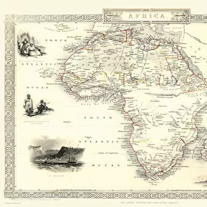
AFRICA: MAP, 15th CENTURY. Tabula Nova Partis Africae

![]()
Wall Art and Photo Gifts from Granger
AFRICA: MAP, 15th CENTURY. Tabula Nova Partis Africae
AFRICA: MAP, 15th CENTURY.
Tabula Nova Partis Africae. A late 15th century map of Africa from the Cosmographia of Ptolemy, showing the headlands and rivers with names given by Portuguese navigators. The unknown has been filled in with mythical data
Granger holds millions of images spanning more than 25,000 years of world history, from before the Stone Age to the dawn of the Space Age
Media ID 12320965
15th Century Africa African Age Of Exploration Claudius Coast Cosmographia Universalis Exploration Imaginary Mountain Myth New World Portuguese Ptolemy Scepter Seashore Southern
FEATURES IN THESE COLLECTIONS
> Africa
> Related Images
> Animals
> Mammals
> Soricidae
> Navigator
> Arts
> Landscape paintings
> Waterfall and river artworks
> River artworks
> Granger Art on Demand
> Maps
> Maps and Charts
> World
MADE IN THE USA
Safe Shipping with 30 Day Money Back Guarantee
FREE PERSONALISATION*
We are proud to offer a range of customisation features including Personalised Captions, Color Filters and Picture Zoom Tools
FREE COLORIZATION SERVICE
You can choose advanced AI Colorization for this picture at no extra charge!
SECURE PAYMENTS
We happily accept a wide range of payment options so you can pay for the things you need in the way that is most convenient for you
* Options may vary by product and licensing agreement. Zoomed Pictures can be adjusted in the Cart.