Home > Arts > Photorealistic artworks > Detailed art pieces > Masterful detailing in art
Positioning of the South Pole

![]()
Wall Art and Photo Gifts from Mary Evans Picture Library
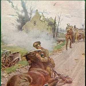
Positioning of the South Pole
A detailed map of the South Pole in position to other countries in the world. It shows the positioning of the different land masses across islands and countries. Date: 1912
Mary Evans Picture Library makes available wonderful images created for people to enjoy over the centuries
Media ID 32251492
© Illustrated London News Ltd/Mary Evans
Antarctic Countries Geography Perspective Plateau Pole
FEATURES IN THESE COLLECTIONS
> Arts
> Photorealistic artworks
> Detailed art pieces
> Masterful detailing in art
> Europe
> France
> Canton
> Landes
> Maps and Charts
> Related Images
> Maps and Charts
> World
> Mary Evans Prints Online
> New Images July 2023
EDITORS COMMENTS
This evocative and intricately detailed map, published in 1912, provides a captivating perspective of the South Pole's position in the global landscape. Produced by the Illustrated London News (ILN) - Consolidated Archive Holdings Ltd, this Edwardian-era map offers a unique insight into the geographical understanding of the world during a time when the South Pole was still largely unexplored. The map meticulously illustrates the positioning of the South Pole in relation to various countries and landmasses across the world. The icy expanse of Antarctica, with its myriad of islands and land formations, is depicted in stunning detail. The Ross Ice Shelf, Ronne Ice Shelf, and the Transantarctic Mountains are all clearly marked, providing a sense of the vast and inhospitable terrain that early explorers faced. At the heart of the map lies the South Pole itself, marked by a simple red dot. Surrounding it are the territorial claims of various nations, including New Zealand, Australia, and Norway. The map also highlights the various expeditions that had reached the continent up to that point, including those led by Robert Falcon Scott and Roald Amundsen. The map's intricate detail and meticulous accuracy offer a fascinating glimpse into the geographical knowledge of the early 20th century. It serves as a reminder of the human fascination with the unknown and the lengths to which explorers went to uncover the mysteries of our world. With its antiquated yet captivating design, this map is a testament to the enduring allure of the South Pole and the spirit of exploration that continues to drive us forward.
MADE IN THE USA
Safe Shipping with 30 Day Money Back Guarantee
FREE PERSONALISATION*
We are proud to offer a range of customisation features including Personalised Captions, Color Filters and Picture Zoom Tools
SECURE PAYMENTS
We happily accept a wide range of payment options so you can pay for the things you need in the way that is most convenient for you
* Options may vary by product and licensing agreement. Zoomed Pictures can be adjusted in the Cart.