Home > Europe > United Kingdom > Wales > Powys > Montgomery
Dacorum HP2 4 Map

![]()
Wall Art and Photo Gifts from Map Marketing
Dacorum HP2 4 Map
Postcode Sector Map of Dacorum HP2 4
Media ID 19971391
A414 Albion Hill Alexandra Road Arundel Close Badgers Croft Barley Croft Blackberry Way Blossom Way Bluebell Walk Broad Street Broadfield Road Burleigh Road Burnet Close Caernarvon Close Caister Close Chilham Close Clayton Drive Crescent Road Curtis Road Dacorum Denbigh Close Eden Drive Fern Drive Field Road Grange Close Green Lane Greenacres Hammer Lane Hillary Road Hillfield Road Homefield Road Kenilworth Close Leaside Lombardy Close Longlands Mayflower Avenue Maynard Road Midland Road Montgomery Avenue Morpeth Close Newfield Lane Oakhill Close Orchid Drive Paradise Park Lane Pelham Court Ranelagh Road Rowan Close Ryecroft Close Sherbourne Close St Albans Road St Davids Close St Margarets Way The Chase The Coppice The Driftway The Holt The Sidings The Spires Trinity Mews Vauxhall Road Walnut Grove White Hart Road Windmill Road Wolsey Road Wood Lane
FEATURES IN THESE COLLECTIONS
> Arts
> Portraits
> Pop art gallery
> Street art portraits
> Europe
> United Kingdom
> Wales
> Pembrokeshire
> St Davids
> Europe
> United Kingdom
> Wales
> Powys
> Montgomery
> Map Marketing
> Postcode Sector Maps
> HP - Hemel Hempstead
> Maps and Charts
> Related Images
> Transportation
> Aeroplanes
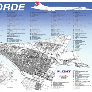
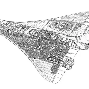
> Concorde
MADE IN THE USA
Safe Shipping with 30 Day Money Back Guarantee
FREE PERSONALISATION*
We are proud to offer a range of customisation features including Personalised Captions, Color Filters and Picture Zoom Tools
SECURE PAYMENTS
We happily accept a wide range of payment options so you can pay for the things you need in the way that is most convenient for you
* Options may vary by product and licensing agreement. Zoomed Pictures can be adjusted in the Cart.