Home > Europe > United Kingdom > England > Worcestershire > Bromsgrove
Bromsgrove Worcestershire B47 6 Map

![]()
Wall Art and Photo Gifts from Map Marketing
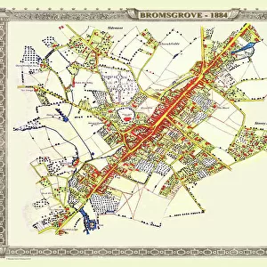
Bromsgrove Worcestershire B47 6 Map
Postcode Sector Map of Bromsgrove Worcestershire B47 6
Media ID 19965463
Alcester Road Ash Crescent Aspen Grove Avon Drive Barkers Lane Brick Kiln Lane Burnham Road Chapel Drive Chapel Lane Church Close Church View Franklin Close Fulford Close Gorsey Lane Green Close Hastings Close Hill Lane Manor Road Meadow Croft Meadow Road Middle Lane Mill Lane Norton Lane School Drive Severn Way Silver Street Station Road The Laurels The Lawns The Oaks The Spinney The Willows
FEATURES IN THESE COLLECTIONS
> Arts
> Portraits
> Pop art gallery
> Street art portraits
> Europe
> United Kingdom
> England
> Avon
> Europe
> United Kingdom
> England
> Worcestershire
> Bromsgrove
> Europe
> United Kingdom
> England
> Worcestershire
> Related Images
> Map Marketing
> Postcode Sector Maps
> B - Birmingham
> Maps and Charts
> Related Images
MADE IN THE USA
Safe Shipping with 30 Day Money Back Guarantee
FREE PERSONALISATION*
We are proud to offer a range of customisation features including Personalised Captions, Color Filters and Picture Zoom Tools
SECURE PAYMENTS
We happily accept a wide range of payment options so you can pay for the things you need in the way that is most convenient for you
* Options may vary by product and licensing agreement. Zoomed Pictures can be adjusted in the Cart.