Jigsaw Puzzle > Europe > United Kingdom > England > Related Images
Jigsaw Puzzle : London, infrared satellite image C016 / 3889


![]()
Jigsaw Puzzles From Science Photo Library
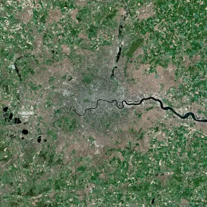
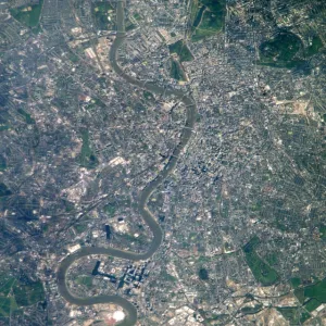
London, infrared satellite image C016 / 3889
London and its surrounds, infrared satellite image. North is at top. The Thames Estuary is at right. This view is used for studies of vegetation, as different types and densities of plants reflect infrared light in different ways. Coniferous forests appear darker red than hardwoods. Deep red hues indicate dense vegetation, while lighter reds indicate grasslands or sparsely vegetated areas. Image data obtained on 13 September 2002 by the Enhanced Thematic Mapper Plus (bands 4, 3, 2) on NASAs Landsat 7 satellite. For a true-colour and an alternative infrared version of this view, see images C016/3888 and C016/3890
Science Photo Library features Science and Medical images including photos and illustrations
Media ID 9204327
© NASA/ROBERT SIMMON/USGS/SCIENCE PHOTO LIBRARY
2002 Capital Cities City Coast Countryside Earth Observation Enhanced Thematic Mapper Plus Essex Fields From Space Greater London Human Geography Infrared Kent Land Land Cover Land Use Landsat 7 Largest London Region Rivers Rural Satellite Satellite Image Sequence Series Suburban Surrey Thames Thames Estuary Town Towns Urban Vegetation Built Up Middlesex South East England Surroundings Surrounds
Jigsaw Puzzle (1014 Pieces)
Discover a unique perspective of London with the Media Storehouse Infrared Satellite Jigsaw Puzzle C016 / 3889. This captivating puzzle, brought to you by NASA, Robert Simmon, USGS, and Science Photo Library, invites you to piece together an extraordinary image of London as seen from an infrared satellite. Explore the intricacies of the Thames Estuary and the vibrant greens of the urban landscape, perfect for both puzzle enthusiasts and armchair explorers. Immerse yourself in the wonders of satellite technology and geography with this one-of-a-kind jigsaw puzzle experience.
Made in the USA, 1014-piece puzzles measure 20" x 30" (50.8 x 76.2 cm). Every puzzle is meticulously printed on glossy photo paper, which has a strong 1.33 mm thickness. Delivered in a black storage cardboard box, these puzzles are both stylish and practical. (Note: puzzles contain small parts and are not suitable for children under 3 years of age.)
Jigsaw Puzzles are an ideal gift for any occasion
Estimated Product Size is 76cm x 50.8cm (29.9" x 20")
These are individually made so all sizes are approximate
Artwork printed orientated as per the preview above, with landscape (horizontal) orientation to match the source image.
FEATURES IN THESE COLLECTIONS
> Europe
> Related Images
> Europe
> United Kingdom
> England
> London
> Related Images
> Europe
> United Kingdom
> England
> Related Images
> Europe
> United Kingdom
> Related Images
EDITORS COMMENTS
This print showcases a mesmerizing infrared satellite image of London and its surrounding areas. The image, taken on September 13,2002, by NASA's Landsat 7 satellite using the Enhanced Thematic Mapper Plus, provides valuable insights into vegetation studies. With north positioned at the top and the Thames Estuary visible on the right side, this view offers a unique perspective of England's capital city. The varying shades of red in this image indicate different types and densities of vegetation. Coniferous forests appear as darker red hues compared to hardwoods. Deep red tones signify dense vegetation, while lighter shades represent grasslands or sparsely vegetated regions. As one explores this photograph further, it becomes evident that it captures not only London but also parts of Middlesex, Surrey, Essex, Kent, and Greater London. From urban landscapes to rural countryside scenes with rivers flowing through fields and towns nestled amidst greenery – this image encapsulates the diverse land use patterns found in South East England. Providing an extraordinary glimpse from space into Earth's human geography during the early years of the 21st century, this remarkable satellite image is a testament to NASA's commitment to earth observation. It serves as a reminder of our planet's intricate beauty and highlights how technology can aid us in understanding our surroundings better.
MADE IN THE USA
Safe Shipping with 30 Day Money Back Guarantee
FREE PERSONALISATION*
We are proud to offer a range of customisation features including Personalised Captions, Color Filters and Picture Zoom Tools
SECURE PAYMENTS
We happily accept a wide range of payment options so you can pay for the things you need in the way that is most convenient for you
* Options may vary by product and licensing agreement. Zoomed Pictures can be adjusted in the Basket.