Jigsaw Puzzle > Europe > United Kingdom > England > Birmingham > Area > Aston
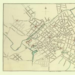
Jigsaw Puzzle : Old Map of Aston Manor near Birmingham 1796


![]()
Jigsaw Puzzles From MapSeeker
Old Map of Aston Manor near Birmingham 1796
J122
Welcome to the Mapseeker Image library and enter an historic gateway to one of the largest on-line collections of Historic Maps, Nostalgic Views, Vista's and Panorama's from a World gone by.
Media ID 20346937
Birmingham Birmingham City Birmingham City Map Birmingham Map Birmingham Town Plan Historic Birmingham Map Historic Map Map Of Birmingham Old Map Of Birmingham Old Town Plan Town Plan Of Birmingham
Jigsaw Puzzle (1014 Pieces)
Discover the rich history of Aston Manor near Birmingham with our captivating Old Map Jigsaw Puzzle (J122) from Media Storehouse. This intricately detailed puzzle, featuring an Old Map of Aston Manor dated 1796 from MapSeeker, offers an engaging and educational experience. Immerse yourself in the past as you piece together the intricacies of this vintage map, revealing the beauty and charm of this historic area. A perfect activity for puzzle enthusiasts, history buffs, or anyone seeking a fun and rewarding challenge.
Made in the USA, 1014-piece puzzles measure 20" x 30" (50.8 x 76.2 cm). Every puzzle is meticulously printed on glossy photo paper, which has a strong 1.33 mm thickness. Delivered in a black storage cardboard box, these puzzles are both stylish and practical. (Note: puzzles contain small parts and are not suitable for children under 3 years of age.)
Jigsaw Puzzles are an ideal gift for any occasion
Estimated Product Size is 76cm x 50.8cm (29.9" x 20")
These are individually made so all sizes are approximate
Artwork printed orientated as per the preview above, with landscape (horizontal) orientation to match the source image.
FEATURES IN THESE COLLECTIONS
> Europe
> United Kingdom
> England
> Birmingham
> Area
> Aston
> MapSeeker
> British Town And City Plans
> English & Welsh PORTFOLIO
EDITORS COMMENTS
This print showcases an exquisite piece of history, the "Old Map of Aston Manor near Birmingham 1796 (J122)". Steeped in rich heritage and intricate details, this map offers a fascinating glimpse into the past. As we delve into its depths, we are transported back to the year 1796 when Aston Manor was a thriving community near Birmingham. The carefully preserved lines and markings on this historic map reveal the layout and structure of Aston Manor during that era. Every street, building, and landmark is meticulously depicted with remarkable precision. It serves as a testament to the craftsmanship and artistry of cartographers from centuries ago. Through this old town plan, we can explore how Aston Manor fit within the larger context of Birmingham at that time. The map not only provides geographical information but also offers insights into the social fabric and economic activities prevalent in this bustling area. As our eyes wander across each delicate stroke on this print, it becomes evident that it is more than just a mere representation of land; it encapsulates stories waiting to be discovered. This visual treasure invites us to embark on a journey through time as we unravel forgotten tales hidden within its contours. Whether you are an avid historian or simply captivated by maps' allure, this print will transport you back in time while offering endless opportunities for exploration and discovery.
MADE IN THE USA
Safe Shipping with 30 Day Money Back Guarantee
FREE PERSONALISATION*
We are proud to offer a range of customisation features including Personalised Captions, Color Filters and Picture Zoom Tools
SECURE PAYMENTS
We happily accept a wide range of payment options so you can pay for the things you need in the way that is most convenient for you
* Options may vary by product and licensing agreement. Zoomed Pictures can be adjusted in the Basket.