Canvas Print > Europe > United Kingdom > England > Birmingham > Area > Aston
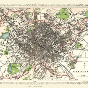
Canvas Print : Old Map of Aston Manor near Birmingham 1796


![]()
Canvas Prints From MapSeeker
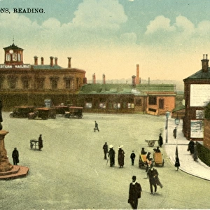
Old Map of Aston Manor near Birmingham 1796
J122
Welcome to the Mapseeker Image library and enter an historic gateway to one of the largest on-line collections of Historic Maps, Nostalgic Views, Vista's and Panorama's from a World gone by.
Media ID 20346937
Birmingham Birmingham City Birmingham City Map Birmingham Map Birmingham Town Plan Historic Birmingham Map Historic Map Map Of Birmingham Old Map Of Birmingham Old Town Plan Town Plan Of Birmingham
30"x20" (76x51cm) Canvas Print
Step back in time with our Old Map of Aston Manor near Birmingham 1796 Canvas Print from Media Storehouse and MapSeeker. This beautiful, vintage map offers a captivating glimpse into the past, showcasing intricate details of the Aston Manor area as it appeared over 200 years ago. The high-quality canvas print brings the history to life, with vivid colors and impressive detail that make it a stunning addition to any room. Perfect for history enthusiasts, map collectors, or anyone who appreciates the beauty of the past, this canvas print is sure to become a cherished conversation piece in your home or office.
Delivered stretched and ready to hang our premium quality canvas prints are made from a polyester/cotton blend canvas and stretched over a 1.25" (32mm) kiln dried knot free wood stretcher bar. Packaged in a plastic bag and secured to a cardboard insert for safe transit.
Canvas Prints add colour, depth and texture to any space. Professionally Stretched Canvas over a hidden Wooden Box Frame and Ready to Hang
Estimated Product Size is 76.2cm x 50.8cm (30" x 20")
These are individually made so all sizes are approximate
Artwork printed orientated as per the preview above, with landscape (horizontal) orientation to match the source image.
FEATURES IN THESE COLLECTIONS
> Europe
> United Kingdom
> England
> Birmingham
> Area
> Aston
> MapSeeker
> British Town And City Plans
> English & Welsh PORTFOLIO
EDITORS COMMENTS
This print showcases an exquisite piece of history, the "Old Map of Aston Manor near Birmingham 1796 (J122)". Steeped in rich heritage and intricate details, this map offers a fascinating glimpse into the past. As we delve into its depths, we are transported back to the year 1796 when Aston Manor was a thriving community near Birmingham. The carefully preserved lines and markings on this historic map reveal the layout and structure of Aston Manor during that era. Every street, building, and landmark is meticulously depicted with remarkable precision. It serves as a testament to the craftsmanship and artistry of cartographers from centuries ago. Through this old town plan, we can explore how Aston Manor fit within the larger context of Birmingham at that time. The map not only provides geographical information but also offers insights into the social fabric and economic activities prevalent in this bustling area. As our eyes wander across each delicate stroke on this print, it becomes evident that it is more than just a mere representation of land; it encapsulates stories waiting to be discovered. This visual treasure invites us to embark on a journey through time as we unravel forgotten tales hidden within its contours. Whether you are an avid historian or simply captivated by maps' allure, this print will transport you back in time while offering endless opportunities for exploration and discovery.
MADE IN THE USA
Safe Shipping with 30 Day Money Back Guarantee
FREE PERSONALISATION*
We are proud to offer a range of customisation features including Personalised Captions, Color Filters and Picture Zoom Tools
SECURE PAYMENTS
We happily accept a wide range of payment options so you can pay for the things you need in the way that is most convenient for you
* Options may vary by product and licensing agreement. Zoomed Pictures can be adjusted in the Basket.