Jigsaw Puzzle > Asia > Related Images
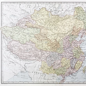
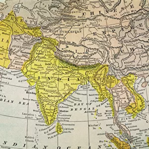
Jigsaw Puzzle : MAP: EAST ASIA, 1907. Map of East Asia, 1907, published in the United States


![]()
Jigsaw Puzzles From Granger
MAP: EAST ASIA, 1907. Map of East Asia, 1907, published in the United States
Granger holds millions of images spanning more than 25,000 years of world history, from before the Stone Age to the dawn of the Space Age
Media ID 6617321
1907 China Chinese East Empire Filipino Japan Japanese Korea Korean Philippine Philippines
Jigsaw Puzzle (520 Pieces)
Discover the rich history of East Asia with our captivating jigsaw puzzle from Media Storehouse. This intriguing puzzle features a vintage map of East Asia, published in the United States in 1907, by The Granger Collection from Granger Art on Demand. Immerse yourself in the intricate details of this map, which showcases the political boundaries and geographical features of the region during that time. With vibrant colors and stunning detail, this puzzle is perfect for history enthusiasts, puzzle collectors, or anyone looking for a challenging and rewarding pastime. Bring the past to life and create a beautiful display piece once completed.
Made in the USA, 520-piece puzzles measure 16" x 20" (40.6 x 50.8 cm). Every puzzle is meticulously printed on glossy photo paper, which has a strong 1.33 mm thickness. Delivered in a black storage cardboard box, these puzzles are both stylish and practical. (Note: puzzles contain small parts and are not suitable for children under 3 years of age.)
Jigsaw Puzzles are an ideal gift for any occasion
Estimated Product Size is 40.5cm x 50.8cm (15.9" x 20")
These are individually made so all sizes are approximate
Artwork printed orientated as per the preview above, with landscape (horizontal) or portrait (vertical) orientation to match the source image.
FEATURES IN THESE COLLECTIONS
> Granger Art on Demand
> Maps
> Asia
> Philippines
> Related Images
> Asia
> Related Images
EDITORS COMMENTS
MAP: EAST ASIA, 1907. A captivating glimpse into the geopolitical landscape of early 20th century East Asia is captured in this vintage map print. Published in the United States, this meticulously detailed map offers a fascinating snapshot of the region's political boundaries and cultural diversity during that era. The map prominently showcases China, Japan, and Korea as major players on the Asian continent. It highlights important cities, rivers, and mountain ranges while providing valuable insights into their historical significance. The Chinese Empire stands out with its vast territory and rich heritage, while Japan emerges as a rising power with its own distinct identity. Notably, this map also includes the Philippines—a former Spanish colony—reflecting an interesting chapter in East Asian history when Western powers exerted influence over these lands. The presence of Korean territories further underscores the complex dynamics between neighboring nations at that time. As we delve deeper into this visual treasure trove from Granger Art on Demand, it becomes evident how maps serve not only as navigational tools but also as windows to our past. This particular piece invites us to explore the intricate tapestry of cultures and histories that have shaped East Asia throughout centuries. Whether you are a history enthusiast or simply appreciate beautiful cartography, this vintage map print is sure to spark curiosity about bygone eras and inspire conversations about our ever-evolving world.
MADE IN THE USA
Safe Shipping with 30 Day Money Back Guarantee
FREE PERSONALISATION*
We are proud to offer a range of customisation features including Personalised Captions, Color Filters and Picture Zoom Tools
SECURE PAYMENTS
We happily accept a wide range of payment options so you can pay for the things you need in the way that is most convenient for you
* Options may vary by product and licensing agreement. Zoomed Pictures can be adjusted in the Basket.