Home > Arts > Landscape paintings > Waterfall and river artworks > River artworks
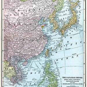
MAP: EUROPE IN ASIA. Map of Asia, English, c1935, emphasizing the territorial acquistitions of the Russian and British Empires up

![]()
Wall Art and Photo Gifts from Granger
MAP: EUROPE IN ASIA. Map of Asia, English, c1935, emphasizing the territorial acquistitions of the Russian and British Empires up
MAP: EUROPE IN ASIA. Map of Asia, English, c1935, emphasizing the territorial acquistitions of the Russian and British Empires up to 1914
Granger holds millions of images spanning more than 25,000 years of world history, from before the Stone Age to the dawn of the Space Age
Media ID 6617405
1914 Asia British Empire Colonialism Colony Russia Russian
FEATURES IN THESE COLLECTIONS
> Arts
> Landscape paintings
> Waterfall and river artworks
> River artworks
> Asia
> Related Images
> Granger Art on Demand
> Maps
> Maps and Charts
> British Empire Maps
> Maps and Charts
> Early Maps
EDITORS COMMENTS
This print titled "MAP: EUROPE IN ASIA" takes us back to the year 1935, showcasing a historically significant map of Asia. The focus of this English map is on the territorial acquisitions made by two powerful empires - Russia and Britain - leading up to the year 1914. The intricate details depicted in this print highlight the extent of Russian and British colonialism during that era. It serves as a visual reminder of how these empires expanded their influence across vast regions, leaving an indelible mark on Asian history. The map showcases not only political boundaries but also major rivers that played crucial roles in shaping these conquests. As we explore this image, we are transported back in time, witnessing the early stages of Russian expansion into Asia and the strategic moves made by the British Empire to establish colonies throughout the continent. Through this print from The Granger Collection, we gain insight into a pivotal period when global powers sought dominance over new territories. It sparks curiosity about how these imperialistic endeavors impacted both European nations and Asian societies alike. As we delve deeper into this historical artifact, it becomes evident that maps hold immense power in unraveling stories from our past. This particular piece invites us to reflect upon an era defined by exploration, conquests, and geopolitical shifts – ultimately reminding us of Europe's lasting presence within Asia's borders.
MADE IN THE USA
Safe Shipping with 30 Day Money Back Guarantee
FREE PERSONALISATION*
We are proud to offer a range of customisation features including Personalised Captions, Color Filters and Picture Zoom Tools
SECURE PAYMENTS
We happily accept a wide range of payment options so you can pay for the things you need in the way that is most convenient for you
* Options may vary by product and licensing agreement. Zoomed Pictures can be adjusted in the Cart.