Jigsaw Puzzle > Europe > United Kingdom > England > Maps
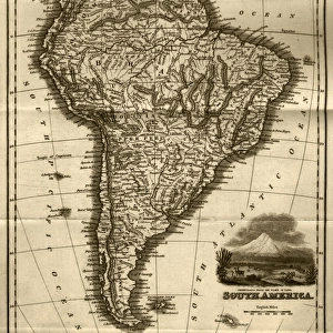
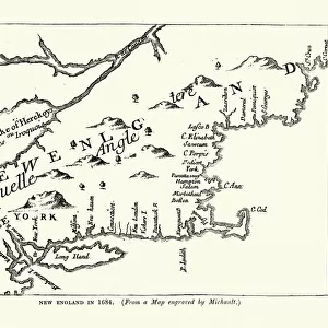
Jigsaw Puzzle : Map of New England, early 18th Century


![]()
Jigsaw Puzzles from Fine Art Storehouse
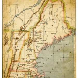
Map of New England, early 18th Century
Vintage engraving of a Map of New England, early 18th Century
Unleash your creativity and transform your space into a visual masterpiece!
duncan1890
Media ID 18563412
© of Duncan P Walker
18th Century 18th Century Style
Jigsaw Puzzle (520 Pieces)
Discover the rich history of New England with our captivating jigsaw puzzle from Media Storehouse. Featuring an intricately detailed vintage engraving by duncan1890 from Fine Art Storehouse, this Map of New England from the early 18th Century is a delight for history enthusiasts and puzzle lovers alike. Transport yourself back in time as you piece together this intricate puzzle, revealing the early settlements and landmarks that shaped the New World. A perfect addition to any home or office, this challenging yet rewarding puzzle is sure to provide hours of enjoyment and a beautiful display once completed.
Made in the USA, 520-piece puzzles measure 16" x 20" (40.6 x 50.8 cm). Every puzzle is meticulously printed on glossy photo paper, which has a strong 1.33 mm thickness. Delivered in a black storage cardboard box, these puzzles are both stylish and practical. (Note: puzzles contain small parts and are not suitable for children under 3 years of age.)
Jigsaw Puzzles are an ideal gift for any occasion
Estimated Product Size is 40.5cm x 50.8cm (15.9" x 20")
These are individually made so all sizes are approximate
Artwork printed orientated as per the preview above, with landscape (horizontal) or portrait (vertical) orientation to match the source image.
FEATURES IN THESE COLLECTIONS
> Fine Art Storehouse
> Map
> Historical Maps
> Europe
> United Kingdom
> England
> Maps
> Europe
> United Kingdom
> England
> Posters
> Europe
> United Kingdom
> England
> Related Images
> Maps and Charts
> Early Maps
> Maps and Charts
> Related Images
EDITORS COMMENTS
This vintage engraving takes us back to the early 18th century, offering a glimpse into the intricate cartography of New England. The print showcases an antique map meticulously crafted in the distinctive style of that era. Every detail is carefully etched, revealing the region's geographical features, towns, rivers, and coastlines with remarkable precision. As we delve into this historical masterpiece by Duncan1890 from Fine Art Storehouse, we are transported to a time when exploration and discovery were at their peak. This map serves as a testament to the curiosity and ingenuity of those who sought to understand and navigate this vast land. The monochromatic palette adds an air of elegance and timelessness to the piece. It invites us to appreciate not only its artistic value but also its historical significance. Through this print, we can imagine early settlers relying on maps like these for guidance as they embarked on arduous journeys across uncharted territories. Whether you're an avid history enthusiast or simply captivated by artistry from centuries past, this exquisite print will undoubtedly become a cherished addition to any collection. Its ability to transport us through time while showcasing both beauty and functionality makes it a true treasure worth exploring further.
MADE IN THE USA
Safe Shipping with 30 Day Money Back Guarantee
FREE PERSONALISATION*
We are proud to offer a range of customisation features including Personalised Captions, Color Filters and Picture Zoom Tools
SECURE PAYMENTS
We happily accept a wide range of payment options so you can pay for the things you need in the way that is most convenient for you
* Options may vary by product and licensing agreement. Zoomed Pictures can be adjusted in the Cart.