Home > Europe > United Kingdom > England > Maps
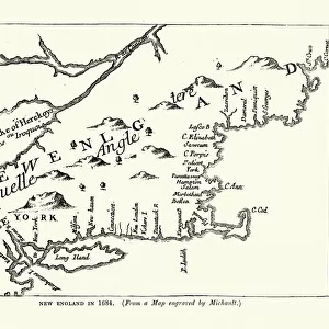
Captain John Smiths map of New England, 17th Century

![]()
Wall Art and Photo Gifts from Fine Art Storehouse
Captain John Smiths map of New England, 17th Century
Vintage engraving of Captain John Smiths map of New England, 17th Century
Unleash your creativity and transform your space into a visual masterpiece!
duncan1890
Media ID 18298715
© of Duncan P Walker
FEATURES IN THESE COLLECTIONS
> Europe
> United Kingdom
> England
> Maps
> Fine Art Storehouse
> Map
> Historical Maps
> Maps and Charts
> Early Maps
EDITORS COMMENTS
This vintage engraving showcases Captain John Smith's map of New England from the 17th century. A true treasure for history enthusiasts, this print takes us back in time to an era when exploration and discovery were at their peak. The intricate details of the map are a testament to Captain John Smith's remarkable cartographic skills and his deep understanding of the region. Every line and curve on this piece tells a story, revealing the vastness of uncharted territories waiting to be explored. As we gaze upon this print, we can almost imagine ourselves sailing alongside Captain Smith as he navigated through treacherous waters and encountered indigenous tribes along the way. It serves as a reminder of the bravery and determination that characterized those early explorers who ventured into unknown lands. The sepia tones add a touch of nostalgia, enhancing our connection with history while evoking a sense of wonder about what lies beyond the edges of this ancient map. This artwork is not just an aesthetic delight; it also invites us to delve deeper into our past, sparking curiosity about how these lands have evolved over centuries. Whether displayed in a study or showcased in a gallery setting, this vintage engraving is sure to captivate viewers with its rich historical significance and artistic allure. It stands as both an homage to Captain John Smith's contributions and an invitation for us all to embark on our own journeys of discovery – whether they be literal or metaphorical – inspired by those who came before us.
MADE IN THE USA
Safe Shipping with 30 Day Money Back Guarantee
FREE PERSONALISATION*
We are proud to offer a range of customisation features including Personalised Captions, Color Filters and Picture Zoom Tools
SECURE PAYMENTS
We happily accept a wide range of payment options so you can pay for the things you need in the way that is most convenient for you
* Options may vary by product and licensing agreement. Zoomed Pictures can be adjusted in the Cart.