Canvas Print > Europe > United Kingdom > England > Maps
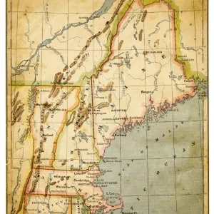
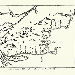
Canvas Print : Map of New England, early 18th Century


![]()
Canvas Prints from Fine Art Storehouse
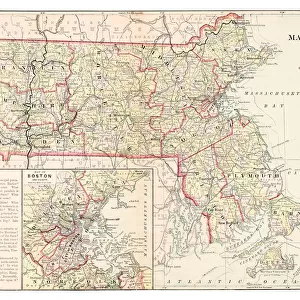
Map of New England, early 18th Century
Vintage engraving of a Map of New England, early 18th Century
Unleash your creativity and transform your space into a visual masterpiece!
duncan1890
Media ID 18563412
© of Duncan P Walker
18th Century 18th Century Style
20"x16" (51x41cm) Canvas Print
Step back in time with our exquisite Canvas Print of a Vintage Map of New England, early 18th Century, by duncan1890 from our Media Storehouse Fine Art collection. This beautiful engraving transports you to an era of discovery and history. The intricate details of the map are brought to life in vibrant colors on high-quality canvas, making it a stunning addition to any room in your home or office. Perfect for history enthusiasts, cartography lovers, or those who appreciate the beauty of vintage art, this Canvas Print is sure to be a conversation starter and a cherished piece in your personal collection.
Delivered stretched and ready to hang our premium quality canvas prints are made from a polyester/cotton blend canvas and stretched over a 1.25" (32mm) kiln dried knot free wood stretcher bar. Packaged in a plastic bag and secured to a cardboard insert for safe transit.
Canvas Prints add colour, depth and texture to any space. Professionally Stretched Canvas over a hidden Wooden Box Frame and Ready to Hang
Estimated Product Size is 40.6cm x 50.8cm (16" x 20")
These are individually made so all sizes are approximate
Artwork printed orientated as per the preview above, with portrait (vertical) orientation to match the source image.
FEATURES IN THESE COLLECTIONS
> Europe
> United Kingdom
> England
> Maps
> Europe
> United Kingdom
> England
> Posters
> Europe
> United Kingdom
> England
> Related Images
> Maps and Charts
> Early Maps
> Maps and Charts
> Related Images
> Fine Art Storehouse
> Map
> Historical Maps
EDITORS COMMENTS
This vintage engraving takes us back to the early 18th century, offering a glimpse into the intricate cartography of New England. The print showcases an antique map meticulously crafted in the distinctive style of that era. Every detail is carefully etched, revealing the region's geographical features, towns, rivers, and coastlines with remarkable precision. As we delve into this historical masterpiece by Duncan1890 from Fine Art Storehouse, we are transported to a time when exploration and discovery were at their peak. This map serves as a testament to the curiosity and ingenuity of those who sought to understand and navigate this vast land. The monochromatic palette adds an air of elegance and timelessness to the piece. It invites us to appreciate not only its artistic value but also its historical significance. Through this print, we can imagine early settlers relying on maps like these for guidance as they embarked on arduous journeys across uncharted territories. Whether you're an avid history enthusiast or simply captivated by artistry from centuries past, this exquisite print will undoubtedly become a cherished addition to any collection. Its ability to transport us through time while showcasing both beauty and functionality makes it a true treasure worth exploring further.
MADE IN THE USA
Safe Shipping with 30 Day Money Back Guarantee
FREE PERSONALISATION*
We are proud to offer a range of customisation features including Personalised Captions, Color Filters and Picture Zoom Tools
SECURE PAYMENTS
We happily accept a wide range of payment options so you can pay for the things you need in the way that is most convenient for you
* Options may vary by product and licensing agreement. Zoomed Pictures can be adjusted in the Cart.