Fine Art Print > Europe > United Kingdom > England > Maps
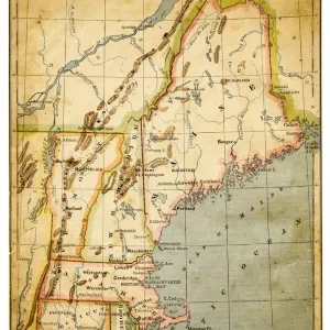
Fine Art Print : Map of New England, early 18th Century


![]()
Fine Art Prints from Fine Art Storehouse
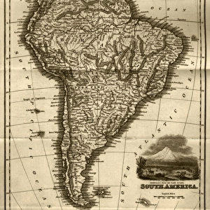
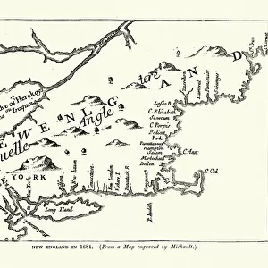
Map of New England, early 18th Century
Vintage engraving of a Map of New England, early 18th Century
Unleash your creativity and transform your space into a visual masterpiece!
duncan1890
Media ID 18563412
© of Duncan P Walker
18th Century 18th Century Style
20"x16" (+3" Border) Fine Art Print
Step back in time with our exquisite Map of New England print from the Fine Art Storehouse collection. This vintage engraving, created in the early 18th century by the talented artist duncan1890, offers a captivating glimpse into the history of the New England region. The intricate details and authentic antique aesthetic transport you to a bygone era, making this a stunning addition to any home or office. Bring history to life with this beautiful fine art print.
20x16 image printed on 26x22 Fine Art Rag Paper with 3" (76mm) white border. Our Fine Art Prints are printed on 300gsm 100% acid free, PH neutral paper with archival properties. This printing method is used by museums and art collections to exhibit photographs and art reproductions.
Our fine art prints are high-quality prints made using a paper called Photo Rag. This 100% cotton rag fibre paper is known for its exceptional image sharpness, rich colors, and high level of detail, making it a popular choice for professional photographers and artists. Photo rag paper is our clear recommendation for a fine art paper print. If you can afford to spend more on a higher quality paper, then Photo Rag is our clear recommendation for a fine art paper print.
Estimated Image Size (if not cropped) is 40.6cm x 50.8cm (16" x 20")
Estimated Product Size is 55.9cm x 66cm (22" x 26")
These are individually made so all sizes are approximate
Artwork printed orientated as per the preview above, with portrait (vertical) orientation to match the source image.
FEATURES IN THESE COLLECTIONS
> Europe
> United Kingdom
> England
> Maps
> Europe
> United Kingdom
> England
> Posters
> Europe
> United Kingdom
> England
> Related Images
> Maps and Charts
> Early Maps
> Maps and Charts
> Related Images
> Fine Art Storehouse
> Map
> Historical Maps
EDITORS COMMENTS
This vintage engraving takes us back to the early 18th century, offering a glimpse into the intricate cartography of New England. The print showcases an antique map meticulously crafted in the distinctive style of that era. Every detail is carefully etched, revealing the region's geographical features, towns, rivers, and coastlines with remarkable precision. As we delve into this historical masterpiece by Duncan1890 from Fine Art Storehouse, we are transported to a time when exploration and discovery were at their peak. This map serves as a testament to the curiosity and ingenuity of those who sought to understand and navigate this vast land. The monochromatic palette adds an air of elegance and timelessness to the piece. It invites us to appreciate not only its artistic value but also its historical significance. Through this print, we can imagine early settlers relying on maps like these for guidance as they embarked on arduous journeys across uncharted territories. Whether you're an avid history enthusiast or simply captivated by artistry from centuries past, this exquisite print will undoubtedly become a cherished addition to any collection. Its ability to transport us through time while showcasing both beauty and functionality makes it a true treasure worth exploring further.
MADE IN THE USA
Safe Shipping with 30 Day Money Back Guarantee
FREE PERSONALISATION*
We are proud to offer a range of customisation features including Personalised Captions, Color Filters and Picture Zoom Tools
SECURE PAYMENTS
We happily accept a wide range of payment options so you can pay for the things you need in the way that is most convenient for you
* Options may vary by product and licensing agreement. Zoomed Pictures can be adjusted in the Cart.