Framed Print > Europe > United Kingdom > England > Oxfordshire > Henley on Thames
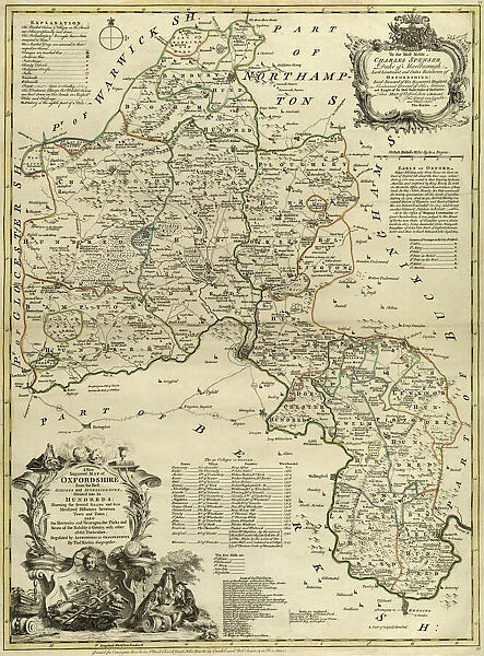
Framed Print : County Map of Oxfordshire, c. 1777
![]()

Framed Photos from Sheffield City Archives
County Map of Oxfordshire, c. 1777
From The Large English Atlas: or, a new set of map of all the counties of England and Wales drawn from the several surveys which have been hitherto been published. With three general maps of England, Scotland and Ireland, from the latest and best authorities, by Emanuel Bowen, Thomas Kitchin and others. London, printed and sold by T. Bowles, [c.1777]
Original at Sheffield Libraries: 912 STF
Sheffield City Archives and Local Studies Library has an unrivalled collection of images of Sheffield, England
Media ID 25501475
© Sheffield City Council - All Rights Reserved
Antique Map Bowens Map County Map Emanuel Bowen Old Map Thomas Kitchin Abingdon Banbury Bicester Chipping Norton Henley On Thames Oxfordshire Thame Wallingford Wantage Witney Woodstock
12"x10" Modern Frame
Step back in time with our exquisite framed print featuring a rare and captivating County Map of Oxfordshire, dating back to 1777. This stunning antique map, sourced from the Sheffield City Archives, is taken from The Large English Atlas. Bring a touch of history and character to your home or office with this beautifully preserved piece, expertly framed to preserve its original charm. Perfect for map enthusiasts, history buffs, or those who appreciate the beauty of vintage cartography. Add this unique and intriguing conversation starter to your collection today.
10x8 Print in an MDF Wooden Frame with 180 gsm Satin Finish Paper. Glazed using shatter proof thin plexi glass. Frame thickness is 1 inch and depth 0.75 inch. Fluted cardboard backing held with clips. Supplied ready to hang with sawtooth hanger and rubber bumpers. Spot clean with a damp cloth. Packaged foam wrapped in a card.
Contemporary Framed and Mounted Prints - Professionally Made and Ready to Hang
Estimated Image Size (if not cropped) is 25.4cm x 25.4cm (10" x 10")
Estimated Product Size is 25.4cm x 30.5cm (10" x 12")
These are individually made so all sizes are approximate
Artwork printed orientated as per the preview above, with landscape (horizontal) or portrait (vertical) orientation to match the source image.
FEATURES IN THESE COLLECTIONS
> Europe
> United Kingdom
> England
> Oxfordshire
> Henley on Thames
> Sheffield City Archives
> Maps and Plans
> Bowen's County Maps, c. 1777
EDITORS COMMENTS
This print showcases the exquisite "County Map of Oxfordshire" dating back to approximately 1777. A true treasure from "The Large English Atlas: or, a new set of map of all the counties of England and Wales" this antique map was meticulously crafted by renowned cartographers Emanuel Bowen, Thomas Kitchin, and others. With its intricate details and remarkable accuracy, this historical piece offers a glimpse into the past as it unveils the enchanting landscapes and towns that make up Oxfordshire. From bustling urban centers like Abingdon, Bicester, Banbury, and Witney to idyllic rural retreats such as Chipping Norton, Wantage, Great Farringdon, and Thame – every corner is beautifully depicted. As you explore this mesmerizing artwork further, your eyes will be drawn to notable landmarks like Henley-on-Thames with its picturesque riverside charm or Wallingford's rich history emanating from its ancient walls. The grandeur of Woodstock can also be admired on this map – a town steeped in regal heritage due to its proximity to Blenheim Palace. Preserved within Sheffield Libraries' archives for generations before being immortalized in this photo print; it serves as a testament to our enduring fascination with maps as windows into our collective history. So take a moment to immerse yourself in the beauty of old-world cartography through this remarkable County Map of Oxfordshire - an extraordinary piece that transcends time itself.
MADE IN THE USA
Safe Shipping with 30 Day Money Back Guarantee
FREE PERSONALISATION*
We are proud to offer a range of customisation features including Personalised Captions, Color Filters and Picture Zoom Tools
SECURE PAYMENTS
We happily accept a wide range of payment options so you can pay for the things you need in the way that is most convenient for you
* Options may vary by product and licensing agreement. Zoomed Pictures can be adjusted in the Cart.


