Framed Print > Europe > United Kingdom > England > Related Images
Framed Print : London, true-colour satellite image C016 / 3888


![]()
Framed Photos From Science Photo Library
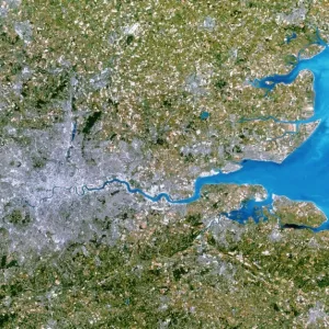
London, true-colour satellite image C016 / 3888
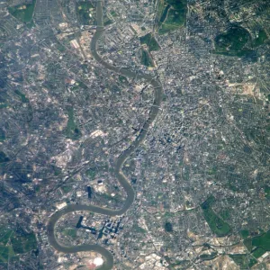
London and its surrounds, true-colour satellite image. North is at top. The Thames Estuary is at right. London is the capital city of the UK. It has been the largest and most populous city in Europe since the 17th century, and is a major financial and cultural centre. The centre of London is at centre left, with the Thames flowing through it towards the estuary. The area shown here is around 170 kilometres across, and includes extensive areas of fields. Image data obtained on 13 September 2002 by the Enhanced Thematic Mapper Plus (bands 3, 2, 1) on NASAs Landsat 7 satellite. For infrared versions of this view, see images C016/3889 and C016/3890
Science Photo Library features Science and Medical images including photos and illustrations
Media ID 9204337
© NASA/ROBERT SIMMON/USGS/SCIENCE PHOTO LIBRARY
2002 Capital Cities City Coast Countryside Earth Observation Enhanced Thematic Mapper Plus Essex Fields From Space Greater London Human Geography Kent Land Land Cover Land Use Landsat 7 Largest London Natural Region Rivers Rural Satellite Satellite Image Sequence Series Suburban Surrey Thames Thames Estuary Town Towns True Colour Urban Built Up Middlesex South East England Surroundings Surrounds True Color
18"x14" Modern Frame
Discover a unique perspective of London with our Media Storehouse Framed Print featuring a stunning true-colour satellite image from NASA, captured by Robert Simmon of the USGS Science Photo Library. Witness the breathtaking view of London and its surroundings as you've never seen it before - with the iconic Thames River winding through the city and the urban landscape stretching out in every direction. This framed print is a must-have for anyone who appreciates the beauty of our planet and the wonders of space technology. Add a touch of awe-inspiring art to your home or office decor.
16x12 Print in an MDF Wooden Frame with 180 gsm Satin Finish Paper. Glazed using shatter proof thin plexiglass. Frame thickness is 1 inch and depth 0.75 inch. Fluted cardboard backing held with clips. Supplied ready to hang with sawtooth hanger and rubber bumpers. Spot clean with a damp cloth. Packaged foam wrapped in a card.
Contemporary Framed and Mounted Prints - Professionally Made and Ready to Hang
Estimated Image Size (if not cropped) is 40.6cm x 35.6cm (16" x 14")
Estimated Product Size is 45.7cm x 35.6cm (18" x 14")
These are individually made so all sizes are approximate
Artwork printed orientated as per the preview above, with landscape (horizontal) orientation to match the source image.
FEATURES IN THESE COLLECTIONS
> Europe
> Related Images
> Europe
> United Kingdom
> England
> London
> Related Images
> Europe
> United Kingdom
> England
> Related Images
> Europe
> United Kingdom
> Related Images
EDITORS COMMENTS
This print showcases a true-colour satellite image of London and its surrounds. With the North at the top, the Thames Estuary gracefully flows on the right side of the frame. As the capital city of the United Kingdom, London has held its position as Europe's largest and most populous city since the 17th century. Renowned for its financial prowess and cultural significance, this metropolis is depicted in all its glory. The heart of London sits prominently towards the center-left, with the iconic River Thames meandering through it before reaching out to embrace the estuary. The vastness captured in this image spans approximately 170 kilometers across, encompassing extensive fields that add a touch of rural beauty to an otherwise urban landscape. Obtained on September 13th, 2002 by NASA's Landsat 7 satellite using Enhanced Thematic Mapper Plus technology (bands 3,2,1), this photograph offers a glimpse into London's intricate tapestry from space. It provides valuable insight into land use patterns and covers Greater London along with surrounding areas such as Middlesex, Surrey, Essex, Kent - showcasing both built-up urban regions and picturesque countryside. This remarkable visual representation serves as a testament to human geography in England during our modern era. Its breathtaking details reveal how cities have evolved over time while harmonizing with their natural surroundings. A truly awe-inspiring piece capturing one of Europe's most vibrant cities from above.
MADE IN THE USA
Safe Shipping with 30 Day Money Back Guarantee
FREE PERSONALISATION*
We are proud to offer a range of customisation features including Personalised Captions, Color Filters and Picture Zoom Tools
SECURE PAYMENTS
We happily accept a wide range of payment options so you can pay for the things you need in the way that is most convenient for you
* Options may vary by product and licensing agreement. Zoomed Pictures can be adjusted in the Basket.