Framed Print > Fine Art Storehouse > Map
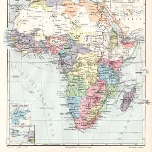
Framed Print : Main research trips in Africa 1895


![]()
Framed Photos from Fine Art Storehouse
Main research trips in Africa 1895
Meyers Konversations-Lexikon. Ein Nachschlagewerk des allgemeinen Wissens, 5th edition 17 volumes Bibliographisches Institut - Leipzig 1895-1897
Unleash your creativity and transform your space into a visual masterpiece!
THEPALMER
Media ID 13611763
© This content is subject to copyright
Algeria Atlas Mythological Figure Central Africa East Africa Egypt Exploration Journey Madagascar Middle East Morocco North Africa Paper Politics Politics And Government Research Sahara Desert World Map
12"x10" Modern Frame
Step back in time with our exquisite framed print, "Main research trips in Africa 1895" by THEPALMER from our Media Storehouse Fine Art Collection. This captivating image is taken from the renowned Meyers Konversations-Lexikon, 5th edition, published by Bibliographisches Institut in Leipzig between 1895 and 1897. The vintage illustration beautifully showcases the spirit of exploration during the late 19th century in Africa. Each print is carefully framed to preserve its historical charm and add a touch of elegance to your home or office decor. Embrace the rich heritage of the past with our Framed Prints from the Fine Art Storehouse.
10x8 Print in an MDF Wooden Frame with 180 gsm Satin Finish Paper. Glazed using shatter proof thin plexi glass. Frame thickness is 1 inch and depth 0.75 inch. Fluted cardboard backing held with clips. Supplied ready to hang with sawtooth hanger and rubber bumpers. Spot clean with a damp cloth. Packaged foam wrapped in a card.
Contemporary Framed and Mounted Prints - Professionally Made and Ready to Hang
Estimated Image Size (if not cropped) is 25.4cm x 25.4cm (10" x 10")
Estimated Product Size is 25.4cm x 30.5cm (10" x 12")
These are individually made so all sizes are approximate
Artwork printed orientated as per the preview above, with landscape (horizontal) or portrait (vertical) orientation to match the source image.
FEATURES IN THESE COLLECTIONS
> Fine Art Storehouse
> The Magical World of Illustration
> Palmer Illustrated Collection
> Fine Art Storehouse
> Map
> Historical Maps
> Fine Art Storehouse
> Map
> USA Maps
> Fine Art Storehouse
> Travel Imagery
> Travel Destinations
> Morocco, North Africa
> Fine Art Storehouse
> Ultimate Earth Prints
> Amazing Deserts
EDITORS COMMENTS
This print titled "Main research trips in Africa 1895" takes us on a mesmerizing journey through time and space. With its origins dating back to the late 19th century, this image is an engraved illustration from Meyers Konversations-Lexikon, a renowned encyclopedia of general knowledge. The vertical composition showcases an intricate world map, meticulously crafted by skilled cartographers of that era. It highlights the vastness and diversity of Africa's landscapes, as well as key regions such as Madagascar, Egypt, North Africa, East Africa, Morocco, Central Africa, Algeria, and even parts of the Sahara Desert. As we delve into this antique piece of artistry and exploration, it becomes evident that it represents more than just physical geography. The inclusion of political boundaries suggests a deeper understanding of politics and government during that period. This print serves as a visual testament to the extensive research conducted by intrepid explorers who ventured into uncharted territories across continents. It offers us a glimpse into their tireless efforts to expand our knowledge about distant lands. With its rich historical significance and exquisite craftsmanship captured in paper form through engraving techniques prevalent at the time; this artwork holds immense value for collectors or enthusiasts interested in both art history and geographical discovery. THEPALMER has skillfully preserved this treasure from yesteryears for us to appreciate today.
MADE IN THE USA
Safe Shipping with 30 Day Money Back Guarantee
FREE PERSONALISATION*
We are proud to offer a range of customisation features including Personalised Captions, Color Filters and Picture Zoom Tools
SECURE PAYMENTS
We happily accept a wide range of payment options so you can pay for the things you need in the way that is most convenient for you
* Options may vary by product and licensing agreement. Zoomed Pictures can be adjusted in the Cart.