Framed Print > Fine Art Storehouse > Map
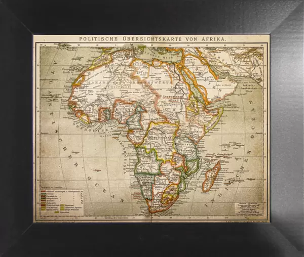
Framed Print : Political outline map of Africa


![]()
Framed Photos from Fine Art Storehouse
Political outline map of Africa
Political outline map of Africa from 1898
Unleash your creativity and transform your space into a visual masterpiece!
Nastasic
Media ID 13592989
© Nikola Nastasic
78279 African Culture Continent Country Geographic Area Geographical Border International Border Nation National Pencil Drawing Politics Politics And Government Region Relief Map Sketch Topography Drawing Art Product Image Created 19th Century Obsolete Painted Image Retro Styled Victorian Style
12"x10" Modern Frame
Step into the past with our exquisite Political Outline Map of Africa Framed Print from Nastasic at Media Storehouse. This fine art piece, sourced from our Fine Art Storehouse, transports you back to 1898 with an intricate depiction of Africa's political boundaries during that era. The detailed map, framed in a sleek and elegant frame, is a captivating addition to any room in your home or office. Bring history to life with this unique and thought-provoking piece. Order now and let the story of Africa's political evolution unfold in your space.
10x8 Print in an MDF Wooden Frame with 180 gsm Satin Finish Paper. Glazed using shatter proof thin plexi glass. Frame thickness is 1 inch and depth 0.75 inch. Fluted cardboard backing held with clips. Supplied ready to hang with sawtooth hanger and rubber bumpers. Spot clean with a damp cloth. Packaged foam wrapped in a card.
Contemporary Framed and Mounted Prints - Professionally Made and Ready to Hang
Estimated Image Size (if not cropped) is 25.4cm x 25.4cm (10" x 10")
Estimated Product Size is 30.5cm x 25.4cm (12" x 10")
These are individually made so all sizes are approximate
Artwork printed orientated as per the preview above, with landscape (horizontal) or portrait (vertical) orientation to match the source image.
FEATURES IN THESE COLLECTIONS
> Fine Art Storehouse
> The Magical World of Illustration
> Nastasic Images & Illustrations
> Fine Art Storehouse
> Map
> Historical Maps
EDITORS COMMENTS
This print showcases a political outline map of Africa, taking us back to the 19th century with its retro and antique style. The image, created in the Victorian era, is a true masterpiece of cartography. Painted with meticulous detail and precision, it resembles an engraved illustration or pencil drawing. The map depicts the international borders and topography of the African continent during that time period. It serves as a historical artifact, shedding light on the political geography of various nations and regions within Africa's vast expanse. Its relief map design adds depth and dimension to this artful representation. As we gaze upon this piece, we are transported to an era when colonial powers were vying for control over African territories. It not only reflects the physical geography but also offers insights into politics and government structures prevalent at that time. With its rich colors and intricate details, this print captures both the beauty of African culture and the complexities of its diverse nations. It stands as a testament to Africa's history while serving as a reminder of how far we have come in our understanding of this magnificent continent. Nastasic has masterfully crafted this drawing art product, offering us an opportunity to appreciate Africa's past through his artistic lens. This horizontal print is perfect for those who appreciate artistry combined with historical significance—a true gem for any collector or enthusiast interested in exploring our world's fascinating past.
MADE IN THE USA
Safe Shipping with 30 Day Money Back Guarantee
FREE PERSONALISATION*
We are proud to offer a range of customisation features including Personalised Captions, Color Filters and Picture Zoom Tools
SECURE PAYMENTS
We happily accept a wide range of payment options so you can pay for the things you need in the way that is most convenient for you
* Options may vary by product and licensing agreement. Zoomed Pictures can be adjusted in the Cart.