Fine Art Print > Arts > Artists > H > Jodocus Hondius
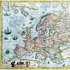
Fine Art Print : 17th century map of Europe


![]()
Fine Art Prints From Science Photo Library
17th century map of Europe
Science Photo Library features Science and Medical images including photos and illustrations
Media ID 6351983
© GEORGETTE DOUWMA/SCIENCE PHOTO LIBRARY
17th Century Ancient Cartography Distorted Distortion Dutch Earth Science Illustrated Inaccurate Incomplete Latin Mapping Maps Mercator Sciences Seventeenth 1606 Gerard Gerardus Hondius Jodocus
20"x16" (+3" Border) Fine Art Print
Discover the rich history of Europe as depicted in this stunning 17th century map from the Science Photo Library's Media Storehouse Fine Art Prints collection. This intricately detailed map transports you back in time, capturing the explorations and discoveries of a bygone era. The vibrant colors and meticulous cartography bring the continent's historical borders and territories to life, making this a must-have addition to any home or office decor. Experience the past like never before with this exquisite fine art print.
20x16 image printed on 26x22 Fine Art Rag Paper with 3" (76mm) white border. Our Fine Art Prints are printed on 300gsm 100% acid free, PH neutral paper with archival properties. This printing method is used by museums and art collections to exhibit photographs and art reproductions.
Our fine art prints are high-quality prints made using a paper called Photo Rag. This 100% cotton rag fibre paper is known for its exceptional image sharpness, rich colors, and high level of detail, making it a popular choice for professional photographers and artists. Photo rag paper is our clear recommendation for a fine art paper print. If you can afford to spend more on a higher quality paper, then Photo Rag is our clear recommendation for a fine art paper print.
Estimated Image Size (if not cropped) is 50.8cm x 40.6cm (20" x 16")
Estimated Product Size is 66cm x 55.9cm (26" x 22")
These are individually made so all sizes are approximate
Artwork printed orientated as per the preview above, with landscape (horizontal) orientation to match the source image.
FEATURES IN THESE COLLECTIONS
> Arts
> Artists
> H
> Jodocus Hondius
> Arts
> Artists
> M
> Gerardus Mercator
> Maps and Charts
> Early Maps
> Maps and Charts
> Gerardus Mercator's Cartographic
> Maps and Charts
> Related Images
EDITORS COMMENTS
This print showcases a remarkable piece of history - a 17th-century map of Europe. The intricate details and artistic flair captured in this illustration transport us back to an era when cartography was still in its infancy. Created by Gerardus Mercator and Jodocus Hondius in 1606, this ancient map offers a unique perspective on the European continent. Its distortion adds an intriguing element, reminding us that accuracy was not always the primary focus during those times. Despite its inaccuracies, this map serves as a testament to the evolving field of geography and the early attempts at mapping our world. The Latin inscription "Nova Europae Descriptio Auctore" further emphasizes the historical significance of this artwork. It invites us to explore Europe through the eyes of these talented Dutch cartographers who meticulously crafted every detail with their expert knowledge. As we gaze upon this incomplete representation, we are reminded that science has come a long way since then. Earth sciences and modern cartography have revolutionized our understanding of geography, making maps more accurate than ever before. Science Photo Library's print allows us to appreciate both the beauty and imperfections within historical maps like these. It is a visual reminder of how far we've come while also honoring the pioneers who laid down foundations for future generations' exploration and discovery.
MADE IN THE USA
Safe Shipping with 30 Day Money Back Guarantee
FREE PERSONALISATION*
We are proud to offer a range of customisation features including Personalised Captions, Color Filters and Picture Zoom Tools
SECURE PAYMENTS
We happily accept a wide range of payment options so you can pay for the things you need in the way that is most convenient for you
* Options may vary by product and licensing agreement. Zoomed Pictures can be adjusted in the Basket.