Home > Europe > United Kingdom > Northern Ireland > Maps
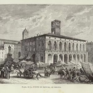
Geographic map of England and France after the Brittany trade in the Hundred Years War in 1360. Lithograph of the 19th century

![]()
Wall Art and Photo Gifts from Fine Art Finder
Geographic map of England and France after the Brittany trade in the Hundred Years War in 1360. Lithograph of the 19th century
NWI4874497 Geographic map of England and France after the Brittany trade in the Hundred Years War in 1360. Lithograph of the 19th century.; (add.info.: Geographic map of England and France after the Brittany trade in the Hundred Years War in 1360. Lithograph of the 19th century.); Photo © North Wind Pictures
Media ID 38335670
© Photo © North Wind Pictures / Bridgeman Images
100 Year War 14 14th Xiv Xivth Fourteenth Century Trecento 1300s 14 14o Xiv Xivo Secolo 14 14th Xiv Xivth Century 14 Century Art Fine Art C14th Geographical Map Late 14th Century The 14th Century Xiv Century Xiv Secolo Xivth Century
FEATURES IN THESE COLLECTIONS
> Europe
> Republic of Ireland
> Maps
> Europe
> United Kingdom
> England
> Maps
> Europe
> United Kingdom
> Maps
> Europe
> United Kingdom
> Northern Ireland
> Maps
> Europe
> United Kingdom
> Northern Ireland
> Posters
> Europe
> United Kingdom
> Northern Ireland
> Related Images
> Fine Art Finder
> Artists
> Spanish School (after)
EDITORS COMMENTS
This stunning lithograph from the 19th century depicts a geographic map of England and France after the Brittany trade in the Hundred Years War in 1360. The intricate details on this print showcase the territorial changes that occurred during this pivotal moment in history.
The borders between England and France are clearly delineated, with Brittany playing a significant role in the negotiations following years of conflict. The map provides a visual representation of how political alliances and power dynamics shifted as a result of this trade agreement.
The colors used in this lithograph bring to life the landscapes of both countries, highlighting their unique geographical features. From the rolling hills of England to the picturesque countryside of France, each region is distinctively portrayed on this map.
As you study this historical document, you can't help but be transported back to the tumultuous times of the 14th century. The attention to detail by the engraver is evident in every line and curve, capturing the essence of Europe during this era.
Whether you're a history buff or simply appreciate fine art, this lithograph is sure to captivate your imagination and spark curiosity about one of the most significant periods in European history.
MADE IN THE USA
Safe Shipping with 30 Day Money Back Guarantee
FREE PERSONALISATION*
We are proud to offer a range of customisation features including Personalised Captions, Color Filters and Picture Zoom Tools
SECURE PAYMENTS
We happily accept a wide range of payment options so you can pay for the things you need in the way that is most convenient for you
* Options may vary by product and licensing agreement. Zoomed Pictures can be adjusted in the Cart.