Home > Africa > Guinea > Maps
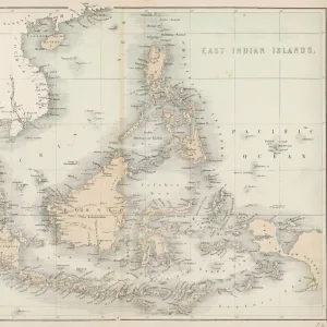
Map of South-Eastern Asia and Northern Australia; Enlarged Map of Tonquin, Annam and Cochhin China (colour litho)
")
![]()
Wall Art and Photo Gifts from Fine Art Finder
Map of South-Eastern Asia and Northern Australia; Enlarged Map of Tonquin, Annam and Cochhin China (colour litho)
1044731 Map of South-Eastern Asia and Northern Australia; Enlarged Map of Tonquin, Annam and Cochhin China (colour litho) by English School, (19th century); Private Collection; (add.info.: Map of South-Eastern Asia and Northern Australia; Enlarged Map of Tonquin, Annam and Cochhin China. Illustration for The Graphic, 22 September 1883.); Look and Learn / Illustrated Papers Collection
Media ID 23543906
© Look and Learn / Illustrated Papers Collection / Bridgeman Images
Annam Districts Java New Guinea Protectorate Queensland Tonquin Volcanic Eruption Northern Australia
FEATURES IN THESE COLLECTIONS
> Fine Art Finder
> Artists
> Charles Emile Auguste Carolus-Duran
> Fine Art Finder
> Artists
> English School
> Fine Art Finder
> Temp Classification
> Maps and Charts
> Related Images
> Oceania
> Australia
> Related Images
EDITORS COMMENTS
This print showcases a vibrant and detailed "Map of South-Eastern Asia and Northern Australia; Enlarged Map of Tonquin, Annam and Cochhin China". Created by the English School in the 19th century, this colour lithograph offers a fascinating glimpse into the geographical landscape of that era. The map highlights various regions, including Tonquin, Annam, Cochhin China, Queensland, Java, New Guinea, and Northern Australia. It also features protectorate districts and volcanic eruptions. The intricate details allow viewers to explore the diverse topography of these areas. Originally published as an illustration for The Graphic on September 22nd in 1883, this artwork provides historical insight into the colonial period when European powers were actively expanding their influence across Southeast Asia. France's presence is particularly notable through its territories depicted on the map. As we observe this piece from Look and Learn / Illustrated Papers Collection housed in a private collection today, it serves as a reminder of how maps have not only been tools for navigation but also windows into cultural exchanges between nations. This particular map reflects French culture within Southeast Asia during that time while showcasing Europe's growing influence globally. Bridgeman Images has preserved this remarkable piece from Fine Art Finder for us to appreciate its beauty and historical significance.
MADE IN THE USA
Safe Shipping with 30 Day Money Back Guarantee
FREE PERSONALISATION*
We are proud to offer a range of customisation features including Personalised Captions, Color Filters and Picture Zoom Tools
SECURE PAYMENTS
We happily accept a wide range of payment options so you can pay for the things you need in the way that is most convenient for you
* Options may vary by product and licensing agreement. Zoomed Pictures can be adjusted in the Cart.