Home > Arts > Artists > C > Abraham Cresques
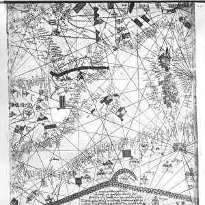
Catalan Atlas, Sheet 12, 1375 (pen and coloured inks on parchment)
")
![]()
Wall Art and Photo Gifts from Fine Art Finder
Catalan Atlas, Sheet 12, 1375 (pen and coloured inks on parchment)
5054646 Catalan Atlas, Sheet 12, 1375 (pen and coloured inks on parchment) by Cresques, Abraham (1325-87); Bibliotheque Nationale, Paris, France; (add.info.: World map made in Majorca, with Jerusalem close to the centre, attributed to the Jewish cartographer Abraham Cresques in the service of the king of Aragon. One of the few surviving examples of medieval cartography, richly illustrated and covers an area from the Atlantic to China, from Scandinavia to the Rio Oro in Africa in six parchment-covered wooden panels.); Spanish, out of copyright
Media ID 23573884
© Bridgeman Images
Atlas Catalan Catalan Atlas Catalonia Compass Compass Lines Cosmography Early Map Hydrography Majorcan Mappa Mundi Nautical Nautical Charts Navigation Navigational Portolan Sea Chart Silk Road Silk Route Spice Trade Spices Travellers Vellum World Map
FEATURES IN THESE COLLECTIONS
> Africa
> Related Images
> Arts
> Art Movements
> Medieval Art
> Arts
> Artists
> C
> Abraham Cresques
> Arts
> Artists
> O
> Oceanic Oceanic
> Asia
> China
> China Heritage Sites
> Silk Roads: the Routes Network of
> Europe
> France
> Paris
> Maps
> Europe
> France
> Paris
> Related Images
> Fine Art Finder
> Artists
> Abraham Cresques
EDITORS COMMENTS
This print showcases the Catalan Atlas, Sheet 12, a remarkable piece of medieval cartography created in 1375 by Abraham Cresques. Crafted with pen and colored inks on parchment, this world map was made in Majorca and is attributed to the Jewish cartographer who served the king of Aragon. The Catalan Atlas stands as one of the few surviving examples of medieval cartography, offering a richly illustrated depiction that spans from Scandinavia to China and from the Atlantic to Africa's Rio Oro. The map covers six parchment-covered wooden panels and features Jerusalem prominently near its center. With its intricate details and vibrant colors, this historical artifact provides valuable insights into early navigation, trade routes such as the Silk Road, maritime exploration, and portolan charts. It serves as a testament to Spain's significant role in global commerce during the 14th century. The Catalan Atlas not only offers geographical information but also presents cosmographic elements like mountains and coastlines. Its navigational significance is evident through compass lines that aid travelers at sea. This manuscript holds immense cultural value for Catalonia while shedding light on Jewish contributions to medieval cartography. Preserved at Bibliotheque Nationale in Paris, France, this extraordinary work continues to captivate viewers with its meticulous craftsmanship and comprehensive portrayal of our world centuries ago.
MADE IN THE USA
Safe Shipping with 30 Day Money Back Guarantee
FREE PERSONALISATION*
We are proud to offer a range of customisation features including Personalised Captions, Color Filters and Picture Zoom Tools
SECURE PAYMENTS
We happily accept a wide range of payment options so you can pay for the things you need in the way that is most convenient for you
* Options may vary by product and licensing agreement. Zoomed Pictures can be adjusted in the Cart.