Fraud Blocker Skip to main content

Home > Europe > France > Paris > Maps

Maps Collection

Maps of Paris, France, Europe are invaluable resources for anyone visiting or living in the city

Choose a picture from our Maps Collection for your Wall Art and Photo Gifts

2,466 items

Background imageMaps Collection: MAP OF FRANCE, c1900. With inset detail of Paris and surrounding area

MAP OF FRANCE, c1900. With inset detail of Paris and surrounding area

Background imageMaps Collection: North and South America map 1887

North and South America map 1887
Map from La Premiere Annee de Geographie par P. Foncin - Paris 1887

Background imageMaps Collection: Poster for French railways to Morocco

Poster for French railways to Morocco
Poster advertising French railways to Morocco, via Paris, Bordeaux, Toulouse and Madrid, to Tangier, Casablanca, Marrakech, and other exotic places

Background imageMaps Collection: A Map of the Lake District, LMS poster, 1923-1947

A Map of the Lake District, LMS poster, 1923-1947
Poster produced for London, Midland & Scottish Railway (LMS) to promote rail travel to the Lake District. Artwork by Arthur Watts (1883-1935), who studied at the Slade Art School and in Antwerp

Background imageMaps Collection: France Administrative Political Map

France Administrative Political Map
A detailed Administrative map of France showing the political administrative divisions of the country. Each Departement is coloured individually

Background imageMaps Collection: Street Map 1878

Street Map 1878
An aerial map of Paris, showing the important monuments and the Seine

Background imageMaps Collection: Map / Paris 18C

Map / Paris 18C
Detailed map of Paris, showing the many churches

Background imageMaps Collection: Le pave de Chailly 1865 (Oil on Canvas)

Le pave de Chailly 1865 (Oil on Canvas)
7212095 Le pave de Chailly 1865 (Oil on Canvas) by Monet, Claude (1840-1926); Musee d Orsay, Paris, France; (add.info.: Le pave de Chailly 1865. Oil on Canvas)

Background imageMaps Collection: Matthew Pariss Map of Great Britain showing rivers & towns in the south of England & part of

Matthew Pariss Map of Great Britain showing rivers & towns in the south of England & part of Wales, c. 1250 (1944)
Many place-names are still recognisable today. The word Auster, written over the English Channel at the bottom, refers to wind bringing heavy cloud cover and fog

Background imageMaps Collection: Map of Paris in 1908 with geographic and demographical data

Map of Paris in 1908 with geographic and demographical data
Map of Paris in 1908 with geographic and demographic data featured (as well as the location of all of the major sites in the city centre). Date: 1908

Background imageMaps Collection: City map of Paris, lithograph, published in 1877

City map of Paris, lithograph, published in 1877
City map of Paris, France. Lithograph, published in 1877

Background imageMaps Collection: Map of the world, 1720

Map of the world, 1720
(Original Caption) 18th century map of the world. Published in Paris in 1720, this French map shows the known world, including the new lands that had been discovered in the preceding centuries by

Background imageMaps Collection: Map of Paris 1900

Map of Paris 1900
Meyers hand-Atlas Leipzig und Wien Verlag des Bibliographischen Instituts 1900

Background imageMaps Collection: City map of Paris

City map of Paris
Antique illustration of a City map of Paris

Background imageMaps Collection: CRESQUES, Jafuda (1350-1410); CRESQUES, Abraham

CRESQUES, Jafuda (1350-1410); CRESQUES, Abraham ( -1381). Catalan Atlas. 1375. Third and Fourth Leaves. Map of the world known in the 14th c. (Finisterre and the Mediterranean)

Background imageMaps Collection: Dark matter map

Dark matter map. Computer model of a dark matter (red) map in part of the universe a billion light years long, the first time the invisible dark matter between visible objects has been mapped

Background imageMaps Collection: Map / Europe / France / Paris

Map / Europe / France / Paris
Map showing the growth of Paris from its earliest origins to the latest projects under Napoleon III

Background imageMaps Collection: Siege of La Rochelle (engraving)

Siege of La Rochelle (engraving)
XIR3050331 Siege of La Rochelle (engraving) by Callot, Jacques (1592-1635); Musee des Plans et Reliefs, Paris, France; (add.info.: The Siege of La Rochelle (French: Le SiAšge de La Rochelle)

Background imageMaps Collection: Map of Mauritius, illustration from Paul et Virginie by Henri Bernardin de Saint-Pierre

Map of Mauritius, illustration from Paul et Virginie by Henri Bernardin de Saint-Pierre
XIR180649 Map of Mauritius, illustration from Paul et Virginie by Henri Bernardin de Saint-Pierre (1737-1814) engraved by Dyonnet, 1836 (coloured engraving) by Dufour, A.H

Background imageMaps Collection: France Alsace-Lorraine map 1887

France Alsace-Lorraine map 1887
Map from La Premiere Annee de Geographie par P. Foncin - Paris 1887

Background imageMaps Collection: Paris, France - City Map

Paris, France - City Map Date: 1830

Background imageMaps Collection: Antique engraving illustration: Paris Subway Metro map

Antique engraving illustration: Paris Subway Metro map

Background imageMaps Collection: The Caverio Map or Caveri Map, circa 1505. This

The Caverio Map or Caveri Map, circa 1505. This map was one of the primary sources used to make the Waldseem� map. Miniature Painting. FRANCE. Paris. National Library

Background imageMaps Collection: Map of Paris

Map of Paris
Bradshaws Plan of Paris, France and map of the environs Date: 19th century

Background imageMaps Collection: PARIS MAP, 1581. Map of Paris, France, by Georg Braun from Civitates Orbis Terarum, 1581

PARIS MAP, 1581. Map of Paris, France, by Georg Braun from Civitates Orbis Terarum, 1581

Background imageMaps Collection: France Waterways map 1887

France Waterways map 1887
Map from La Premiere Annee de Geographie par P. Foncin - Paris 1887

Background imageMaps Collection: Map of Paris 1894

Map of Paris 1894
map/plan of the city of Paris, France

Background imageMaps Collection: Plan of Bremenium, 1902

Plan of Bremenium, 1902. Bremenium was an ancient Roman fort (castra) located at Rochester, Northumberland, England. The fort was one of the defensive structures built along Dere Street

Background imageMaps Collection: Plan of the Defences at Rorkes Drift, (Jan. 22, 1879), c1880

Plan of the Defences at Rorkes Drift, (Jan. 22, 1879), c1880
Plan of the Defences at Rorkes Drift (Jan. 22, 1879), c1880. Episode of the Anglo-Zulu Wars (1879-1896). From British Battles on Land and Sea, Vol. IV, by James Grant

Background imageMaps Collection: Plan of the Marches near Isandhlwana between Jan. 12th and 22nd, 1879, c1880

Plan of the Marches near Isandhlwana between Jan. 12th and 22nd, 1879, c1880. From British Battles on Land and Sea, Vol. IV, by James Grant. [Cassell Petter & Galpin, London, Paris & Melbourne, c1880]

Background imageMaps Collection: Map of industrial Britain in 1881, 1906

Map of industrial Britain in 1881, 1906. From Cassells Illustrated History of England, Vol. VII. [Cassell and Company, Limited, London, Paris, New York & Melbourne, 1906]

Background imageMaps Collection: Map of Cathay, China, from Catalan Atlas created for Charles V, King of France

Map of Cathay, China, from Catalan Atlas created for Charles V, King of France
Cartography, 14th century. Map of Cathay (China). From Catalan Atlas created for Charles V, King of France, attributed to Abraham and Jafuda Cresques Maiorca (circa 1375)

Background imageMaps Collection: Mars map from 1881

Mars map from 1881
Map of Mars, published in Paris in 1881. The first accurate telescope observations of Mars were made in 1877 and 1881 when Mars was at its closest to Earth (a situation called an opposition)

Background imageMaps Collection: Poster, map of the City of Paris

Poster, map of the City of Paris
Poster, three-dimensional map of the City of Paris Date: 1958

Background imageMaps Collection: Plan of the Battle of Aliwal, c1891. Creator: James Grant

Plan of the Battle of Aliwal, c1891. Creator: James Grant
Plan of the Battle of Aliwal, c1891. From " Cassells Illustrated History of India Vol. II.", by James Grant. [Cassell Petter & Galpin, London, Paris and New York]

Background imageMaps Collection: UKRAINIAN, 1875 (oil on canvas)

UKRAINIAN, 1875 (oil on canvas)
7215235 UKRAINIAN, 1875 (oil on canvas) by Repin, Ilya Efimovich (1844-1930); Pushkin Museum, Moscow, Russia; (add.info.: 1875//Oil on canvas In Paris)

Background imageMaps Collection: University of Leiden, Netherlands, 1614 (engraving)

University of Leiden, Netherlands, 1614 (engraving)
7185766 University of Leiden, Netherlands, 1614 (engraving) by Dutch School, (17th century) (after); Private Collection; (add.info.: University of Leiden, founded in 1575 by William)

Background imageMaps Collection: Detail from the Catalan Atlas, 1375 (vellum) (detail of 151844)

Detail from the Catalan Atlas, 1375 (vellum) (detail of 151844)
XZL387496 Detail from the Catalan Atlas, 1375 (vellum) (detail of 151844) by Cresques, Abraham (1325-87); Bibliotheque Nationale, Paris

Background imageMaps Collection: CRESQUES, Jafuda (1350-1410); CRESQUES, Abraham

CRESQUES, Jafuda (1350-1410); CRESQUES, Abraham ( -1381). Catalan Atlas. 1375. Fifth Leaf. Map of Delli. Detail. Camel caravan in the Silk Road to Catai crossing the mountains of Tian Shan

Background imageMaps Collection: Towers of Laon (oil on canvas, 1912)

Towers of Laon (oil on canvas, 1912)
LRI4604779 Towers of Laon (oil on canvas, 1912) by Delaunay, Robert (1885-1941); Musee National d Art Moderne, Centre Pompidou, Paris

Background imageMaps Collection: The meridian Line also known as The Siesta, 1888-1889 (Oil on Canvas)

The meridian Line also known as The Siesta, 1888-1889 (Oil on Canvas)
7212109 The meridian Line also known as The Siesta, 1888-1889 (Oil on Canvas) by Gogh, Vincent van (1853-90); Musee d Orsay, Paris, France; (add.info.: The meridian Line also known as The Siesta)

Background imageMaps Collection: Water Lily Pond, Green Harmony, 1899 (Oil on Canvas)

Water Lily Pond, Green Harmony, 1899 (Oil on Canvas)
7212093 Water Lily Pond, Green Harmony, 1899 (Oil on Canvas) by Monet, Claude (1840-1926); Musee d Orsay, Paris, France; (add.info.: Water Lily Pond, Green Harmony, 1899)

Background imageMaps Collection: Athena guiding Telemachus in his search for Odysseus (colour litho)

Athena guiding Telemachus in his search for Odysseus (colour litho)
7201988 Athena guiding Telemachus in his search for Odysseus (colour litho) by Bonamy, Armand Joseph (fl.1900-30); Private Collection; (add.info.: Athena, disguised as Mentor)

Background imageMaps Collection: Poster for 'Madame Butterfly 'and child with American flag

Poster for "Madame Butterfly "and child with American flag
LSE4093280 Poster for " Madame Butterfly " and child with American flag, poster for the opera by Giacomo Puccini, n.d. deb. 20th S.Ricordi editore

Background imageMaps Collection: Map of the travels of Abraham, Isaac and Jacob, 1652 (engraving)

Map of the travels of Abraham, Isaac and Jacob, 1652 (engraving)
695034 Map of the travels of Abraham, Isaac and Jacob, 1652 (engraving) by Janssonius, Jan (1588-1664) (after); Bibliotheque Nationale, Paris

Background imageMaps Collection: The Empire of Charlemagne (742-814) from Le Nouveau Theatre du Monde

The Empire of Charlemagne (742-814) from Le Nouveau Theatre du Monde
CHT165851 The Empire of Charlemagne (742-814) from Le Nouveau Theatre du Monde, 1639 (coloured engraving) by Hondius, Hendrik I (1573-p.1649); Archives du Ministere des Affaires Etrangeres, Paris

Background imageMaps Collection: Jardin des Tuileries en 1652 (after the plan of Gomboust) - in '

Jardin des Tuileries en 1652 (after the plan of Gomboust) - in "
LSE4101738 Jardin des Tuileries en 1652 (after the plan of Gomboust) - in " Paris a travers les siAcles", by H. Gourdon de Genouillac, ed. F

Background imageMaps Collection: Paris and its Environs, to illustrate the Battle of Paris, 30th March, 1814

Paris and its Environs, to illustrate the Battle of Paris, 30th March, 1814
617389 Paris and its Environs, to illustrate the Battle of Paris, 30th March, 1814, published c.1830s (engraving) by Johnston, Alexander Keith (1804-71); Private Collection; Scottish, out of copyright


All Professionally Made to Order for Quick Shipping


-

Maps Collection

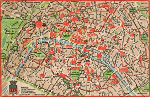
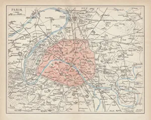
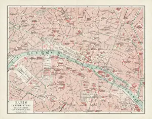
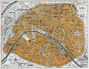
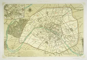
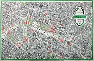
Maps of Paris, France, Europe are invaluable resources for anyone visiting or living in the city. They provide an overview of the city's layout, including its streets and landmarks. They also show public transportation routes and stations, as well as points of interest such as parks and museums. Many it also include information about nearby cities and towns, allowing visitors to plan day trips outside the city limits. Additionally they can help visitors find their way around Paris more easily by providing detailed directions from one point to another. With a map in hand, travelers can explore all that Paris has to offer with confidence.
+

Our beautiful pictures are available as Framed Prints, Photos, Wall Art and Photo Gifts

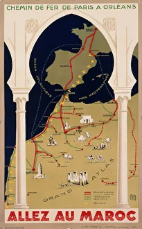
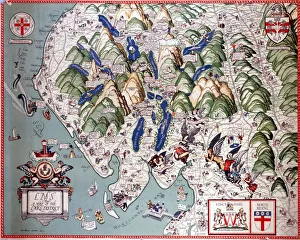
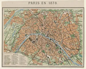
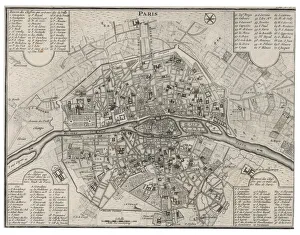
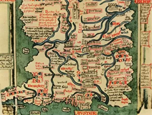
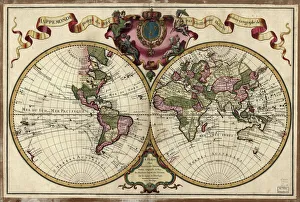
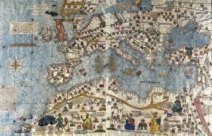
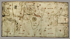
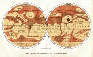
The Maps of Paris France Europe collection from Media Storehouse is a stunning assortment of wall art, framed prints, photo prints, canvas prints, jigsaw puzzles and greeting cards that capture the beauty and history of Paris. Our collection features a wide range of maps depicting different eras in the city's rich cultural heritage. From antique maps dating back to the 18th century to modern-day street maps highlighting popular landmarks such as the Eiffel Tower and Notre-Dame Cathedral, our collection offers something for everyone. Each piece in our collection is carefully crafted using high-quality materials to ensure long-lasting durability and vibrant colors that will stand out on any wall. Whether you're looking for a unique gift or want to add some French charm to your home or office decor, these beautiful pieces are sure to impress. With so many options available at affordable prices, it's easy to find exactly what you need from this impressive selection of artwork.
+

What are Maps of Paris France Europe art prints?

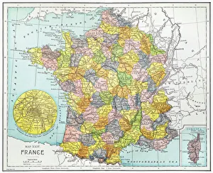
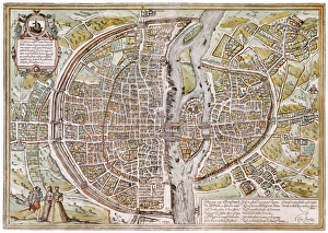
Maps of Paris France Europe art prints are beautiful and detailed depictions of the city of Paris, France, and its surrounding regions. These maps showcase the intricate layout of streets, landmarks, and buildings throughout the area. They are often created using a combination of traditional cartography techniques and modern design elements to produce an aesthetically pleasing representation. These art prints serve as both decorative pieces for your home or office space as well as educational tools for those interested in geography or history. They can be used to plan trips to Paris or simply admired for their artistic value. Maps of Paris France Europe art prints come in various sizes and styles, ranging from vintage designs that capture the essence of old-world charm to contemporary interpretations that reflect modern-day trends. Regardless of your personal style preferences, there is sure to be a map print that will suit your tastes perfectly.
+

What Maps of Paris France Europe art prints can I buy from Media Storehouse?

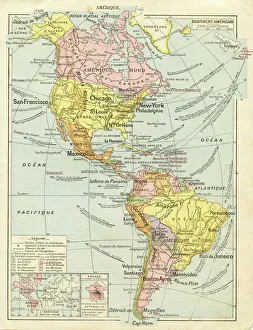
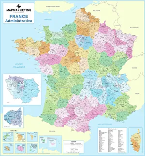
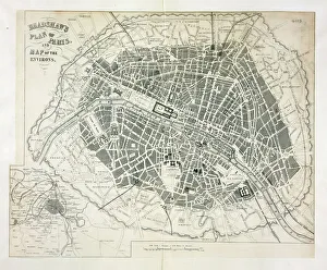
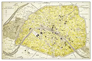
We offer a wide range of Maps of Paris, France and Europe art prints that are perfect for home decor or as gifts. These maps come in various sizes and styles to suit your preferences. You can choose from vintage-style maps that showcase the intricate details of the city's streets, landmarks, and neighborhoods, or modern designs that highlight its vibrant culture and history. Some popular options include detailed street maps of Paris with iconic landmarks such as the Eiffel Tower, Notre Dame Cathedral, and Arc de Triomphe highlighted. There are also antique-style world maps featuring Europe prominently along with other continents. Media Storehouse also offers panoramic views of Paris' skyline at different times of day including sunrise or sunset which make great wall art pieces for any room in your home. Whether you're looking for something classic or contemporary, we have a vast collection of Maps of Paris France Europe art prints to choose from.
+

How do I buy Maps of Paris France Europe art prints?

To buy Maps of Paris France Europe art prints from Media Storehouse, you can browse our extensive collection of maps and select the one that best suits your preferences. Once you have found the map you want to purchase, simply add it to your cart and proceed to checkout. You will be prompted to enter your shipping information and payment details before finalizing your order. We offer a variety of sizes for their art prints, so make sure to choose the size that fits your needs. We also offer different framing options if you prefer a framed print. If you have any questions or concerns about purchasing Maps of Paris France Europe art prints from Media Storehouse, they have a customer service team available to assist you. Simply reach out via email or phone and they will be happy to help guide you through the process.
+

How much do Maps of Paris France Europe art prints cost?

We offer a wide range of Maps of Paris France Europe art prints, which vary in price depending on the size and type of print. The cost for these prints can be affected by factors such as the quality of paper or canvas used, the printing method employed, and any additional features that may be included with the print. However, it is important to note that Media Storehouse strives to offer affordable prices for all their products while maintaining high-quality standards. You can expect reasonable pricing options for Maps of Paris France Europe art prints without compromising on quality. Whether you are looking for vintage maps or contemporary designs, we have something to suit every taste and budget. With a vast collection available online, you can easily browse through different options before making their purchase decision.
+

How will my Maps of Paris France Europe art prints be delivered to me?

We take great care in ensuring that your Maps of Paris France Europe art prints are delivered to you safely and securely. We use high-quality packaging materials to protect your print during transit, so it arrives at your doorstep in pristine condition. Your print will be carefully rolled and placed inside a protective tube before being shipped out to you. This ensures that the print is not damaged or creased during shipping. Additionally, we work with trusted courier services to ensure timely delivery of your order. Once your package has been dispatched, you will receive a tracking number via email which allows you to track the progress of your shipment online. If for any reason there are issues with the delivery of your order, our customer service team is always available to assist you. We hope that receiving your Maps of Paris France Europe art prints brings joy and inspiration into your home or office space.