Home > Historic > World War I and II > World War I
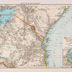
Map Of German East Africa, Showing Jassin, Scene Of One Of Britains Campaigns. From The Illustrated War News Published 1915

![]()
Wall Art and Photo Gifts from Design Pics
Map Of German East Africa, Showing Jassin, Scene Of One Of Britains Campaigns. From The Illustrated War News Published 1915
Design Pics offers Distinctively Different Imagery representing over 1,500 contributors
Media ID 18190605
© Ken Welsh / Design Pics
Africa African Britains East First Geography German Mapmaking Warfare World Campaigns
FEATURES IN THESE COLLECTIONS
> Africa
> Related Images
> Historic
> World War I and II
> World War I
> Maps and Charts
> Related Images
> Maps and Charts
> World
EDITORS COMMENTS
This print takes us back to the year 1915, during the tumultuous times of World War I. The image showcases a detailed map of German East Africa, specifically highlighting Jassin, which served as a significant battleground for one of Britain's campaigns. Published in The Illustrated War News, this historical artifact offers a glimpse into the strategic importance of geography and mapmaking during wartime. As we delve into this snapshot from the past, it becomes evident that this map played an essential role in shaping military tactics and understanding the terrain. With its intricate details and precise markings, it provided crucial information for British forces navigating through unfamiliar African landscapes. The significance of Jassin is emphasized by its prominence on the map. This location witnessed intense warfare between British troops and German forces as both sides vied for control over key territories in East Africa. It serves as a stark reminder of the brutal realities faced by soldiers during World War I. Ken Welsh's expertly captured print allows us to appreciate not only the artistry involved in cartography but also highlights how maps were instrumental tools in shaping strategies during war. As we gaze upon this historic piece, we are transported back to an era where every inch mattered on these meticulously crafted maps – guiding nations through treacherous battlefields with hopes of victory.
MADE IN THE USA
Safe Shipping with 30 Day Money Back Guarantee
FREE PERSONALISATION*
We are proud to offer a range of customisation features including Personalised Captions, Color Filters and Picture Zoom Tools
SECURE PAYMENTS
We happily accept a wide range of payment options so you can pay for the things you need in the way that is most convenient for you
* Options may vary by product and licensing agreement. Zoomed Pictures can be adjusted in the Cart.