Canvas Print > Maps and Charts > Abraham Ortelius
Canvas Print : Rimini, Italy. Theatrum Orbis Terrarum by Abraham Ortelis, 1


![]()
Canvas Prints from Mary Evans Picture Library
Rimini, Italy. Theatrum Orbis Terrarum by Abraham Ortelis, 1
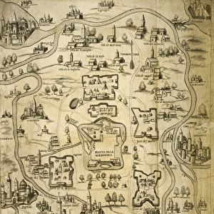
Italy. Rimini city. Theatrum Orbis Terrarum by Abraham Ortelis, 1570. Library Estense. Modena. Italy
Mary Evans Picture Library makes available wonderful images created for people to enjoy over the centuries
Media ID 14337175
© Thaliastock / Mary Evans
1570 Abraham Adriatic Atlas Cartography Emilia Romagna Engraved Geographer Geography Orbis Ortelius Rimini Terrarum Theatrum
30"x20" (76x51cm) Canvas Print
Bring the rich history of Rimini, Italy to your home with our stunning Canvas Print of "Theatrum Orbis Terrarum" by Abraham Ortelis. This exquisite piece, rights managed from Mary Evans Prints Online, showcases the ancient city of Rimini as it appeared in a 1570 map by the renowned cartographer. Add an air of sophistication and intrigue to any room with this beautifully detailed and vibrant canvas print. Each print is professionally printed on high-quality canvas and coated with a protective, archival-grade finish to ensure durability and longevity. Order now and transport yourself to the enchanting streets of Rimini with every glance.
Delivered stretched and ready to hang our premium quality canvas prints are made from a polyester/cotton blend canvas and stretched over a 1.25" (32mm) kiln dried knot free wood stretcher bar. Packaged in a plastic bag and secured to a cardboard insert for safe transit.
Canvas Prints add colour, depth and texture to any space. Professionally Stretched Canvas over a hidden Wooden Box Frame and Ready to Hang
Estimated Product Size is 76.2cm x 50.8cm (30" x 20")
These are individually made so all sizes are approximate
Artwork printed orientated as per the preview above, with landscape (horizontal) orientation to match the source image.
EDITORS COMMENTS
This image is a rare and exquisite glimpse into the past, showcasing the Italian city of Rimini as it appeared in the late 16th century, as depicted in the renowned atlas "Theatrum Orbis Terrarum" by the Flemish cartographer Abraham Ortelius. The engraving, created in 1570, is part of the vast collection housed in the Library Estense in Modena, Italy. The meticulously detailed illustration highlights the strategic location of Rimini along the Adriatic Sea, nestled between the Emilia-Romagna region and the Apennine Mountains. The city's port is clearly visible, with ships anchored in the harbor, signaling the importance of maritime trade during this era. The intricate line work and vibrant colors bring to life the city's architectural gems, including the ancient Arch of Augustus and the imposing Malatesta Temple. This historical map offers a fascinating window into the world of 16th-century geography and cartography, providing a valuable record of the past and a testament to the artistic mastery of Abraham Ortelius.
MADE IN THE USA
Safe Shipping with 30 Day Money Back Guarantee
FREE PERSONALISATION*
We are proud to offer a range of customisation features including Personalised Captions, Color Filters and Picture Zoom Tools
SECURE PAYMENTS
We happily accept a wide range of payment options so you can pay for the things you need in the way that is most convenient for you
* Options may vary by product and licensing agreement. Zoomed Pictures can be adjusted in the Cart.