Home > Europe > France > Canton > Landes
1742 Covens And Mortier Map Of Martinique Topography

![]()
Wall Art and Photo Gifts from Universal Images Group (UIG)
1742 Covens And Mortier Map Of Martinique Topography
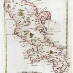
1742, Covens and Mortier Map of Martinique
Universal Images Group (UIG) manages distribution for many leading specialist agencies worldwide
Media ID 38550228
© Artokoloro Quint Lox Limited
1742 Antique Map Latitude Longitude Mappa Mundi Old Antique Plan Old Antique View Ols Antique Map Rare Old Maps Topo
FEATURES IN THESE COLLECTIONS
> Europe
> France
> Canton
> Landes
> Historic
> Space exploration
> Maps and Charts
> Early Maps
> Maps and Charts
> Related Images
> Maps and Charts
> World
> North America
> Martinique
> Maps
> North America
> Martinique
> Related Images
> Universal Images Group (UIG)
> History
> Historical Maps
EDITORS COMMENTS
Step back in time to the 18th century with this stunning print of the Covens and Mortier Map of Martinique, dated 1742. This exquisite illustration is a testament to the art of cartography, showcasing the island's topography with intricate detail and precision.
The map depicts Martinique's rugged landscape, featuring mountains, valleys, rivers, and coastal regions. The geographic boundaries are marked by latitude and longitude lines, giving a sense of depth and dimensionality to the image. The illustration is rendered in beautiful shades of blue and green ink on paper, with subtle wear around the edges adding to its vintage charm.
This historic map not only provides valuable insight into the geography of Martinique during that era but also serves as a fascinating piece of art for any collector or enthusiast. It would be a striking addition to any room or study dedicated to history, travel, or exploration.
Take a journey through time with this rare gem from Universal Images Group (UIG), offering a unique glimpse into the past when navigation was an essential skill for travelers venturing across distant lands.
MADE IN THE USA
Safe Shipping with 30 Day Money Back Guarantee
FREE PERSONALISATION*
We are proud to offer a range of customisation features including Personalised Captions, Color Filters and Picture Zoom Tools
SECURE PAYMENTS
We happily accept a wide range of payment options so you can pay for the things you need in the way that is most convenient for you
* Options may vary by product and licensing agreement. Zoomed Pictures can be adjusted in the Cart.