Home > Europe > France > Canton > Landes
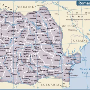
1720 Homann Map Of Transylvania Romania Topography

![]()
Wall Art and Photo Gifts from Universal Images Group (UIG)
1720 Homann Map Of Transylvania Romania Topography
1720, Homann Map of Transylvania, Romania
Universal Images Group (UIG) manages distribution for many leading specialist agencies worldwide
Media ID 38547843
© Artokoloro Quint Lox Limited
1720 Romania Antique Map Latitude Longitude Mappa Mundi Old Antique Plan Old Antique View Ols Antique Map Rare Old Maps Topo
FEATURES IN THESE COLLECTIONS
> Europe
> France
> Canton
> Landes
> Europe
> Romania
> Related Images
> Historic
> Space exploration
> Maps and Charts
> Early Maps
> Maps and Charts
> Related Images
> Maps and Charts
> World
> Universal Images Group (UIG)
> History
> Historical Maps
EDITORS COMMENTS
Step into the 18th century with this stunning print of the 1720 Homann Map of Transylvania, Romania. This exquisite illustration is a testament to the artistry and cartographic skills of its creator, Johann Baptist Homann. The map showcases the topography of Transylvania in remarkable detail, featuring mountains, rivers, forests, and cities etched onto a beautifully rendered grid.
This vintage map is not only a fascinating piece of historical geography but also an impressive work of art. The intricate illustrations and ornate borders add a touch of elegance to this rare find. As you gaze upon this ancient chart, imagine yourself on a journey through time, navigating the winding roads and majestic landscapes that crisscrossed Europe centuries ago.
The Homann Map is more than just a relic from the past; it's a window into the world as it was understood during an era when exploration and discovery were at their peak. This print would make for an extraordinary addition to any collection or home decor scheme. Whether you're an avid history buff or simply appreciate beautiful artwork, this vintage map is sure to captivate your imagination.
MADE IN THE USA
Safe Shipping with 30 Day Money Back Guarantee
FREE PERSONALISATION*
We are proud to offer a range of customisation features including Personalised Captions, Color Filters and Picture Zoom Tools
SECURE PAYMENTS
We happily accept a wide range of payment options so you can pay for the things you need in the way that is most convenient for you
* Options may vary by product and licensing agreement. Zoomed Pictures can be adjusted in the Cart.