Home > Arts > Artists > H > Franz Hogenberg
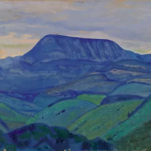
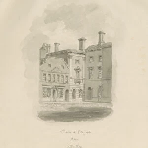
Map of Hertogenbosch, Leuven and Mechelen from Civitates Orbis Terrarum by Georg Braun, 1541-1622 and Franz Hogenberg, 1540-1590, engraving

![]()
Wall Art and Photo Gifts from Universal Images Group (UIG)
Map of Hertogenbosch, Leuven and Mechelen from Civitates Orbis Terrarum by Georg Braun, 1541-1622 and Franz Hogenberg, 1540-1590, engraving
Cartography, Netherlands and Belgium, 16th century. Map of s-Hertogenbosch, Leuven and Mechelen. From Civitates Orbis Terrarum by Georg Braun (1541-1622) and Franz Hogenberg (1540-1590), Cologne. Engraving
Universal Images Group (UIG) manages distribution for many leading specialist agencies worldwide
Media ID 9501185
© DEA / R. MERLO
16th Century Belgium Elevated View Horizon Over Land Manuscript Netherlands Tower Townscape Hertogenbosch Leuven Mechelen
FEATURES IN THESE COLLECTIONS
> Arts
> Art Movements
> Landscapes
> Arts
> Artists
> H
> Franz Hogenberg
> Arts
> Contemporary art
> Landscapes
> Sculptures
> Arts
> Contemporary art
> Sculpture
> Landscape paintings
> Arts
> Landscape paintings
> Landscape art
> Landscape paintings
> Arts
> Landscape paintings
> Landscape art
> Europe
> Belgium
> Paintings
> Universal Images Group (UIG)
> Art
> Painting, Sculpture & Prints
> Cartography
EDITORS COMMENTS
This print showcases a historic map of Hertogenbosch, Leuven, and Mechelen, taken from the renowned Civitates Orbis Terrarum by Georg Braun and Franz Hogenberg. Created in the 16th century, this engraving offers a fascinating glimpse into the cartography of Netherlands and Belgium during that era. The image captures an elevated view of these three towns, revealing their intricate layout and architectural grandeur. The tower structures stand tall against the horizon over land, representing the distinctive character of each city. With no people present in this studio shot, one can focus solely on appreciating the artistry and historical significance behind this masterpiece. The detailed manuscript-like quality adds to its allure as it transports us back to a time when maps were meticulously hand-drawn with precision. This artwork not only serves as an invaluable resource for studying physical geography but also provides insights into the cultural heritage of Belgium and Netherlands. The horizontal composition allows for easy examination of every minute detail within this townscape landscape illustration. As we delve into its rich history through this visual medium, we gain a deeper understanding of how these cities have evolved over centuries. This print is more than just an artistic portrayal; it is a testament to human curiosity about our surroundings and our desire to document them for future generations.
MADE IN THE USA
Safe Shipping with 30 Day Money Back Guarantee
FREE PERSONALISATION*
We are proud to offer a range of customisation features including Personalised Captions, Color Filters and Picture Zoom Tools
SECURE PAYMENTS
We happily accept a wide range of payment options so you can pay for the things you need in the way that is most convenient for you
* Options may vary by product and licensing agreement. Zoomed Pictures can be adjusted in the Cart.