Home > Arts > Artists > C > Samuel de Champlain
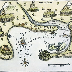
Map of Canada, engraving from survey by Samuel de Champlain, 1632

![]()
Wall Art and Photo Gifts from Universal Images Group (UIG)
Map of Canada, engraving from survey by Samuel de Champlain, 1632
Cartography, 17th century. Map of Canada. Engraving from a survey by Samuel de Champlain, 1632
Universal Images Group (UIG) manages distribution for many leading specialist agencies worldwide
Media ID 9505429
© DEA PICTURE LIBRARY
1632 17th Century Aerial View Border Canada Fortified Wall Guidance Human Settlement Joan Blaeu Navigational Equipment Surrounding Wall Text Wall Non Urban Scene Samuel De Champlain
FEATURES IN THESE COLLECTIONS
> Arts
> Art Movements
> Landscapes
> Arts
> Artists
> B
> Joan Blaeu
> Arts
> Artists
> C
> Samuel de Champlain
> Arts
> Contemporary art
> Landscapes
> Sculptures
> Arts
> Contemporary art
> Sculpture
> Landscape paintings
> Arts
> Landscape paintings
> Landscape art
> Landscape paintings
> Arts
> Landscape paintings
> Landscape art
> Nature-inspired artwork
> Arts
> Landscape paintings
> Landscape art
> Universal Images Group (UIG)
> Art
> Painting, Sculpture & Prints
> Cartography
EDITORS COMMENTS
This print showcases a remarkable piece of history - the Map of Canada, engraved from a survey conducted by Samuel de Champlain in 1632. The intricate details and artistry evident in this 17th-century cartography masterpiece are truly awe-inspiring. The photograph captures the essence of this historical artifact, with its faded yet still discernible topography and text. It is an aerial view that allows us to appreciate the vastness and natural beauty of Canada's landscape as depicted on the map. The surrounding wall adds to the sense of authenticity, reminding us that this map has stood the test of time. As we gaze upon this image, we can't help but imagine what it was like for explorers like Champlain who relied on such maps for guidance during their travels. This engraving served as both a navigational tool and a record of human settlements across Canada at that time. The artistic elements within this print are noteworthy; Joan Blaeu's skillful illustration and painting techniques bring life to every stroke engraved on paper. It is through these works of art that we connect with our past, appreciating how far we have come while acknowledging our roots. In summary, this print offers us a glimpse into history - an opportunity to marvel at the craftsmanship involved in creating such detailed maps centuries ago. It serves as a reminder not only of Canada's rich heritage but also highlights the importance of cartography in understanding our world.
MADE IN THE USA
Safe Shipping with 30 Day Money Back Guarantee
FREE PERSONALISATION*
We are proud to offer a range of customisation features including Personalised Captions, Color Filters and Picture Zoom Tools
SECURE PAYMENTS
We happily accept a wide range of payment options so you can pay for the things you need in the way that is most convenient for you
* Options may vary by product and licensing agreement. Zoomed Pictures can be adjusted in the Cart.