Home > Europe > United Kingdom > England > Sculptures
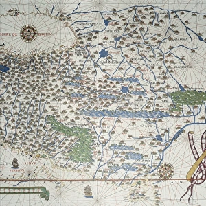
Ireland and Great Britain from a Portolan atlas in three charts, by John Xenodocos from Corfu, 1520

![]()
Wall Art and Photo Gifts from Universal Images Group (UIG)
Ireland and Great Britain from a Portolan atlas in three charts, by John Xenodocos from Corfu, 1520
Cartography, 16th century. Ireland and Great Britain. From a Portolan atlas in three charts, by John Xenodocos from Corfu, 1520, cm. 32 x 22.3
Universal Images Group (UIG) manages distribution for many leading specialist agencies worldwide
Media ID 9502965
© DEA / A. DAGLI ORTI
16th Century Atlas Coastline Complexity Geography Great Britain Ireland Navigation
FEATURES IN THESE COLLECTIONS
> Europe
> Republic of Ireland
> Maps
> Europe
> Republic of Ireland
> Paintings
> Europe
> United Kingdom
> England
> Maps
> Europe
> United Kingdom
> England
> Paintings
> Europe
> United Kingdom
> England
> Sculptures
> Universal Images Group (UIG)
> Art
> Painting, Sculpture & Prints
> Cartography
EDITORS COMMENTS
This print showcases a remarkable piece of cartographic history - "Ireland and Great Britain from a Portolan atlas in three charts" by John Xenodocos from Corfu, dating back to 1520. The image measures approximately 32 x 22.3 cm and offers an intriguing glimpse into the world of navigation and geography during the 16th century. The intricate details within this antique map are truly awe-inspiring. With its horizontal layout, it beautifully captures the coastlines of Ireland, Great Britain, England, and France. The complexity of this illustration is evident as one explores the various regions depicted on the map. As we delve into this artwork's historical significance, we can appreciate how it served as a vital tool for sailors and explorers navigating these European waters centuries ago. It symbolizes not only their quest for new lands but also their understanding of the vastness and diversity of our planet. Through this photo print, we are transported back in time to an era where artistry met functionality in cartography. While there are no people present in this image, its artistic value lies in its ability to convey information through visual representation. Let us marvel at this exquisite piece that bridges art and science - an enduring testament to human curiosity about our world's geographical wonders.
MADE IN THE USA
Safe Shipping with 30 Day Money Back Guarantee
FREE PERSONALISATION*
We are proud to offer a range of customisation features including Personalised Captions, Color Filters and Picture Zoom Tools
SECURE PAYMENTS
We happily accept a wide range of payment options so you can pay for the things you need in the way that is most convenient for you
* Options may vary by product and licensing agreement. Zoomed Pictures can be adjusted in the Cart.