Premium Framed Print > North America > Dominican Republic > Dominican Republic Heritage Sites > Colonial City of Santo Domingo
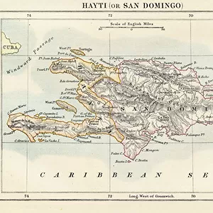
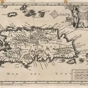
Premium Framed Print : Map of Santo Domingo city showing the citys defensive wall, watercolor, 1619


![]()
Framed Photos from Universal Images Group (UIG)
Map of Santo Domingo city showing the citys defensive wall, watercolor, 1619
Cartography, Dominican Republic, 17th century. Map of Santo Domingo city showing the citys defensive wall, 1619. Watercolor
Universal Images Group (UIG) manages distribution for many leading specialist agencies worldwide
Media ID 9573067
© DEA PICTURE LIBRARY
17th Century Caribbean Sea Coastline Direction Guidance Island Mixed Media Panoramic Santo Domingo Watercolor
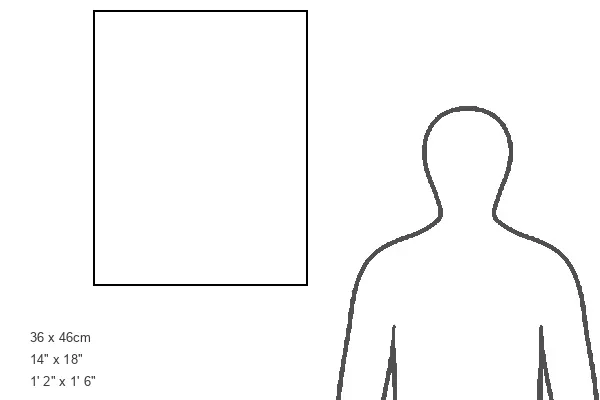
14"x18" Premium Frame
Contemporary style Premium Wooden Frame with 8"x12" Print. Complete with 2" White Mat and 1.25" thick MDF frame. Printed on 260 gsm premium paper. Glazed with shatter proof UV coated acrylic glass. Backing is paper covered backing with rubber bumpers. Supplied ready to hang with a pre-installed sawtooth/wire hanger. Care Instructions: Spot clean with a damp cloth. Securely packaged in a clear plastic bag and envelope in a reinforced cardboard shipper
FSC Real Wood Frame and Double Mounted with White Conservation Mountboard - Professionally Made and Ready to Hang
Estimated Image Size (if not cropped) is 20.3cm x 30.4cm (8" x 12")
Estimated Product Size is 35.6cm x 45.8cm (14" x 18")
These are individually made so all sizes are approximate
Artwork printed orientated as per the preview above, with portrait (vertical) orientation to match the source image.
FEATURES IN THESE COLLECTIONS
> Arts
> Contemporary art
> Mixed media
> Paintings
> Arts
> Watercolor paintings
> Watercolor illustrations
> Maps and Charts
> Related Images
> North America
> Dominican Republic
> Dominican Republic Heritage Sites
> Colonial City of Santo Domingo
> North America
> Dominican Republic
> Maps
> North America
> Dominican Republic
> Related Images
> North America
> Dominican Republic
> Santo Domingo
> Universal Images Group (UIG)
> Art
> Painting, Sculpture & Prints
> Cartography
EDITORS COMMENTS
This watercolor print from 1619 showcases the historical significance of Santo Domingo city, located in the Dominican Republic. The intricate map depicts the city's defensive wall, a testament to its strategic importance during the 17th century. With vibrant hues and delicate brushstrokes, this artwork offers a glimpse into the past and invites us to explore the rich history of this Caribbean island. The panoramic view allows us to appreciate both land and sea, emphasizing how Santo Domingo's location played a crucial role in shaping its destiny. The map serves as a guide, offering direction and insight into the physical geography of the region. As we trace our fingers along its horizontal lines, we can almost feel transported back in time. This mixed media masterpiece combines elements of illustration and painting with watercolors, resulting in an exquisite representation of Santo Domingo's coastline. The absence of people adds an air of mystery while allowing us to focus on appreciating every detail captured by the artist. As we gaze upon this remarkable piece, it is impossible not to be captivated by its beauty and historical significance. It serves as a reminder that art has always been intertwined with cartography - not just for commercial use but also as a means to document history and preserve cultural heritage for generations to come.
MADE IN THE USA
Safe Shipping with 30 Day Money Back Guarantee
FREE PERSONALISATION*
We are proud to offer a range of customisation features including Personalised Captions, Color Filters and Picture Zoom Tools
SECURE PAYMENTS
We happily accept a wide range of payment options so you can pay for the things you need in the way that is most convenient for you
* Options may vary by product and licensing agreement. Zoomed Pictures can be adjusted in the Cart.