Premium Framed Print > Historic > Ancient civilizations > Roman Empire > Ancient Rome
Premium Framed Print : Maps of Italy in ancient times


Framed Photos from North Wind
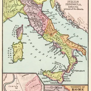
Maps of Italy in ancient times
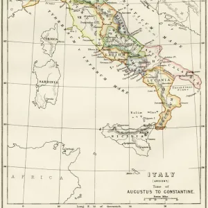
Map of early tribes in Italy (top). of the Roman hills (lower left). and the vicinity of Rome (right) in the time of the Roman Empire.
Printed color lithograph of a 19th-century illustration
North Wind Picture Archives brings history to life with stock images and hand-colored illustrations
Media ID 5878160
© North Wind Picture Archives
Ancient Ancient Civilization Ancient History Ancient Roman Ancient Rome Antiquity Civilization Classical Classical Civilization Europe European Italian Italy Roman Rome Territory Tribe Regions
14"x18" Premium Frame
Contemporary style Premium Wooden Frame with 8"x12" Print. Complete with 2" White Mat and 1.25" thick MDF frame. Printed on 260 gsm premium paper. Glazed with shatter proof UV coated acrylic glass. Backing is paper covered backing with rubber bumpers. Supplied ready to hang with a pre-installed sawtooth/wire hanger. Care Instructions: Spot clean with a damp cloth. Securely packaged in a clear plastic bag and envelope in a reinforced cardboard shipper
FSC Real Wood Frame and Double Mounted with White Conservation Mountboard - Professionally Made and Ready to Hang
Estimated Image Size (if not cropped) is 20.3cm x 30.4cm (8" x 12")
Estimated Product Size is 35.6cm x 45.8cm (14" x 18")
These are individually made so all sizes are approximate
Artwork printed orientated as per the preview above, with portrait (vertical) orientation to match the source image.
FEATURES IN THESE COLLECTIONS
> North Wind Picture Archives
> Ancient history
> North Wind Picture Archives
> Maps
> Arts
> Artists
> R
> Roman Roman
> Europe
> Italy
> Lazio
> Rome
> Historic
> Ancient civilizations
> Roman Empire
> Ancient Rome
> Historic
> Ancient civilizations
> Roman Empire
> Roman art
> Historic
> Ancient civilizations
> Roman Empire
> Historic
> Ancient civilizations
> Maps and Charts
> Early Maps
> Maps and Charts
> Italy
> Maps and Charts
> Related Images
EDITORS COMMENTS
This print showcases the ancient maps of Italy, offering a glimpse into the rich history and civilization that once thrived in this region. The top map depicts the early tribes that inhabited Italy during ancient times, highlighting their territories and boundaries. It serves as a testament to the diverse cultures and societies that coexisted within this land. Moving to the lower left, we encounter a map specifically focusing on the Roman hills. This section provides an intricate view of Rome's surroundings during its glorious days as an empire. It allows us to visualize how these hills played a crucial role in shaping Rome's development and expansion. Lastly, on the right side, we are presented with a detailed depiction of Rome itself during the time of the Roman Empire. This particular map offers insights into its vast territory and showcases its strategic location within Europe. Printed using vibrant colors through lithography techniques from a 19th-century illustration, this vintage artwork exudes classical charm while preserving historical accuracy. Its artistic representation seamlessly combines elements of artistry with factual information about ancient civilizations. Overall, this print is not only visually stunning but also serves as an educational tool for those interested in Italian history, European civilizations, or simply appreciating classical art forms.
MADE IN THE USA
Safe Shipping with 30 Day Money Back Guarantee
FREE PERSONALISATION*
We are proud to offer a range of customisation features including Personalised Captions, Color Filters and Picture Zoom Tools
SECURE PAYMENTS
We happily accept a wide range of payment options so you can pay for the things you need in the way that is most convenient for you
* Options may vary by product and licensing agreement. Zoomed Pictures can be adjusted in the Cart.