Photographic Print > Historic > Ancient civilizations > Roman Empire > Ancient Rome
Photographic Print : Maps of Italy in ancient times

Photo Prints from North Wind
Maps of Italy in ancient times
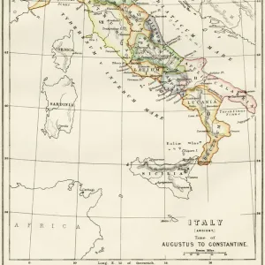
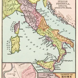
Map of early tribes in Italy (top). of the Roman hills (lower left). and the vicinity of Rome (right) in the time of the Roman Empire.
Printed color lithograph of a 19th-century illustration
North Wind Picture Archives brings history to life with stock images and hand-colored illustrations
Media ID 5878160
© North Wind Picture Archives
Ancient Ancient Civilization Ancient History Ancient Roman Ancient Rome Antiquity Civilization Classical Classical Civilization Europe European Italian Italy Roman Rome Territory Tribe Regions
11"x8.5" Photo Print
Discover the rich history of Italy with Media Storehouse's exquisite range of Photographic Prints from North Wind Picture Archives. This captivating collection includes three distinct maps of ancient Italy, each revealing a unique chapter in the country's storied past. The top print depicts the early tribes of Italy, offering a glimpse into the pre-Roman era and the diverse cultures that once inhabited the land. The lower left print delves into the Roman hills, showcasing the lush, rolling terrain that has been a backdrop to countless tales of ancient history. Rounding out this fascinating trio, the print on the right transports you to the vicinity of Rome during the time of the Roman Empire. Witness the majesty of the Eternal City and its surroundings as they appeared centuries ago, captured in stunning detail in this 19th-century color lithograph. Bring a piece of the past into your home or office with Media Storehouse's Maps of Italy in ancient times Photographic Prints. These beautiful, high-quality prints make for a thoughtful gift or an inspiring addition to any decor. Step back in time and embark on a journey through the history of Italy with these captivating prints.
Photo prints are produced on Kodak professional photo paper resulting in timeless and breath-taking prints which are also ideal for framing. The colors produced are rich and vivid, with accurate blacks and pristine whites, resulting in prints that are truly timeless and magnificent. Whether you're looking to display your prints in your home, office, or gallery, our range of photographic prints are sure to impress. Dimensions refers to the size of the paper in inches.
Our Photo Prints are in a large range of sizes and are printed on Archival Quality Paper for excellent colour reproduction and longevity. They are ideal for framing (our Framed Prints use these) at a reasonable cost. Alternatives include cheaper Poster Prints and higher quality Fine Art Paper, the choice of which is largely dependant on your budget.
Estimated Image Size (if not cropped) is 17.1cm x 27.9cm (6.7" x 11")
Estimated Product Size is 21.6cm x 27.9cm (8.5" x 11")
These are individually made so all sizes are approximate
Artwork printed orientated as per the preview above, with portrait (vertical) orientation to match the source image.
FEATURES IN THESE COLLECTIONS
> North Wind Picture Archives
> Ancient history
> North Wind Picture Archives
> Maps
> Arts
> Artists
> R
> Roman Roman
> Europe
> Italy
> Lazio
> Rome
> Historic
> Ancient civilizations
> Roman Empire
> Ancient Rome
> Historic
> Ancient civilizations
> Roman Empire
> Roman art
> Historic
> Ancient civilizations
> Roman Empire
> Historic
> Ancient civilizations
> Maps and Charts
> Early Maps
> Maps and Charts
> Italy
> Maps and Charts
> Related Images
EDITORS COMMENTS
This print showcases the ancient maps of Italy, offering a glimpse into the rich history and civilization that once thrived in this region. The top map depicts the early tribes that inhabited Italy during ancient times, highlighting their territories and boundaries. It serves as a testament to the diverse cultures and societies that coexisted within this land. Moving to the lower left, we encounter a map specifically focusing on the Roman hills. This section provides an intricate view of Rome's surroundings during its glorious days as an empire. It allows us to visualize how these hills played a crucial role in shaping Rome's development and expansion. Lastly, on the right side, we are presented with a detailed depiction of Rome itself during the time of the Roman Empire. This particular map offers insights into its vast territory and showcases its strategic location within Europe. Printed using vibrant colors through lithography techniques from a 19th-century illustration, this vintage artwork exudes classical charm while preserving historical accuracy. Its artistic representation seamlessly combines elements of artistry with factual information about ancient civilizations. Overall, this print is not only visually stunning but also serves as an educational tool for those interested in Italian history, European civilizations, or simply appreciating classical art forms.
MADE IN THE USA
Safe Shipping with 30 Day Money Back Guarantee
FREE PERSONALISATION*
We are proud to offer a range of customisation features including Personalised Captions, Color Filters and Picture Zoom Tools
SECURE PAYMENTS
We happily accept a wide range of payment options so you can pay for the things you need in the way that is most convenient for you
* Options may vary by product and licensing agreement. Zoomed Pictures can be adjusted in the Cart.