Premium Framed Print > Europe > Spain > Related Images
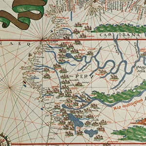
Premium Framed Print : Portolan atlas by Joan Martines (1556-1590). Detail South
. Detail South")
. Detail South")


![]()
Framed Photos From Mary Evans Picture Library
Portolan atlas by Joan Martines (1556-1590). Detail South
Portolan atlas of the world by Joan Martines (1556-1590). Messina, 1587. Detail of South America. Atlantic Coast. National Library. Madrid. Spain
Mary Evans Picture Library makes available wonderful images created for people to enjoy over the centuries
Media ID 14406614
© Thaliastock / Mary Evans
1587 Area Atlantic Atlas Biblioteca Brasil Cartography Chart Colours Element Geography Illuminated Joan Manuscript Martines Nacional Cartographical Cosmographer
14"x16" Premium Frame
Contemporary style Premium Wooden Frame with 8"x10" Print. Complete with 2" White Mat and 1.25" thick MDF frame. Printed on 260 gsm premium paper. Glazed with shatter proof UV coated acrylic glass. Backing is paper covered backing with rubber bumpers. Supplied ready to hang with a pre-installed sawtooth/wire hanger. Care Instructions: Spot clean with a damp cloth. Securely packaged in a clear plastic bag and envelope in a reinforced cardboard shipper
FSC Real Wood Frame and Double Mounted with White Conservation Mountboard - Professionally Made and Ready to Hang
Estimated Image Size (if not cropped) is 25.4cm x 20.3cm (10" x 8")
Estimated Product Size is 40.6cm x 35.6cm (16" x 14")
These are individually made so all sizes are approximate
Artwork printed orientated as per the preview above, with landscape (horizontal) orientation to match the source image.
FEATURES IN THESE COLLECTIONS
> Europe
> Spain
> Related Images
> South America
> Related Images
EDITORS COMMENTS
This stunning detail from the Portolan Atlas by Joan Martines, created in Messina, Italy, in 1587, offers a captivating glimpse into the cartographical knowledge of the late 16th century. The atlas, housed in the National Library of Spain in Madrid, is a testament to the evolution of geographical understanding during this period. The image showcases the Atlantic coast of South America, with Brazil prominently featured. The vibrant colors and intricate decorative elements add an artistic flair to the cartographical representation. The cosmographer, Joan Martines, meticulously charted the coastline with a level of detail previously unseen, reflecting the growing European interest in the New World. The Portolan atlas is a significant historical artifact, providing valuable insights into the geographical knowledge of the time. Its illuminated manuscript pages, adorned with decorative elements, underscore the importance of cartography as a scholarly pursuit. The atlas was not intended for commercial use but rather for the enlightenment of scholars and explorers. This detail of the South American coast, with its colorful representation of the Atlantic waters and the landmasses along the shoreline, offers a glimpse into the rich history of cartography and the fascination with the unknown territories of the world during the 16th century.
MADE IN THE USA
Safe Shipping with 30 Day Money Back Guarantee
FREE PERSONALISATION*
We are proud to offer a range of customisation features including Personalised Captions, Color Filters and Picture Zoom Tools
SECURE PAYMENTS
We happily accept a wide range of payment options so you can pay for the things you need in the way that is most convenient for you
* Options may vary by product and licensing agreement. Zoomed Pictures can be adjusted in the Basket.