Premium Framed Print > Europe > United Kingdom > Scotland > Maps
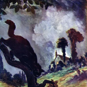
Premium Framed Print : 1860s Victorian Map of the Isle of Arran


![]()
Framed Photos From Mary Evans Picture Library
1860s Victorian Map of the Isle of Arran
Mary Evans Picture Library makes available wonderful images created for people to enjoy over the centuries
Media ID 32350932
© The Keasbury-Gordon Photograph Archive / Mary Evans
14"x18" Premium Frame
Contemporary style Premium Wooden Frame with 8"x12" Print. Complete with 2" White Mat and 1.25" thick MDF frame. Printed on 260 gsm premium paper. Glazed with shatter proof UV coated acrylic glass. Backing is paper covered backing with rubber bumpers. Supplied ready to hang with a pre-installed sawtooth/wire hanger. Care Instructions: Spot clean with a damp cloth. Securely packaged in a clear plastic bag and envelope in a reinforced cardboard shipper
FSC Real Wood Frame and Double Mounted with White Conservation Mountboard - Professionally Made and Ready to Hang
Estimated Image Size (if not cropped) is 20.3cm x 30.4cm (8" x 12")
Estimated Product Size is 35.6cm x 45.8cm (14" x 18")
These are individually made so all sizes are approximate
Artwork printed orientated as per the preview above, with portrait (vertical) orientation to match the source image.
FEATURES IN THESE COLLECTIONS
> Mary Evans Prints Online
> New Images July 2023
> Europe
> United Kingdom
> Scotland
> Maps
> Europe
> United Kingdom
> Scotland
> Posters
> Europe
> United Kingdom
> Scotland
> Related Images
> Maps and Charts
> Early Maps
> Maps and Charts
> Related Images
EDITORS COMMENTS
Step back in time with this stunning 1860s Victorian map of the Isle of Arran. This vintage piece captures the intricate details and charm of a bygone era, showcasing the island's beauty and history in exquisite detail.
The map features Brodick Bay, one of Arran's most picturesque spots, as well as other landmarks that have stood the test of time. From quaint villages to rolling hills, this map offers a glimpse into what life was like on the Isle of Arran during the Victorian era.
Printed on high-quality paper, this Edwardian-era map is a true collector's item for history buffs and lovers of all things vintage. The delicate lines and elegant typography make it a beautiful addition to any home or office space.
Whether you have a connection to Scotland or simply appreciate historical artifacts, this old lantern slide will transport you back in time to an age when maps were meticulously crafted works of art. Explore every corner of Arran through this early depiction that has been preserved for generations to come.
Add a touch of nostalgia and sophistication to your decor with this 1860s Victorian Map of the Isle of Arran from The Keasbury-Gordon Photograph Archive Collection at Mary Evans Prints Online.
MADE IN THE USA
Safe Shipping with 30 Day Money Back Guarantee
FREE PERSONALISATION*
We are proud to offer a range of customisation features including Personalised Captions, Color Filters and Picture Zoom Tools
SECURE PAYMENTS
We happily accept a wide range of payment options so you can pay for the things you need in the way that is most convenient for you
* Options may vary by product and licensing agreement. Zoomed Pictures can be adjusted in the Basket.