Fine Art Print > Europe > United Kingdom > Scotland > Maps
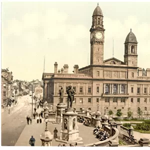
Fine Art Print : 1860s Victorian Map of the Isle of Arran

![]()
Fine Art Prints From Mary Evans Picture Library
1860s Victorian Map of the Isle of Arran
Mary Evans Picture Library makes available wonderful images created for people to enjoy over the centuries
Media ID 32350932
© The Keasbury-Gordon Photograph Archive / Mary Evans
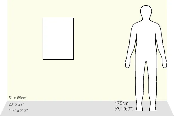
21"x14" (+3" Border) Fine Art Print
Discover the charm of the past with our exquisite Fine Art Print from The Keasbury-Gordon Photograph Archive Collection at Media Storehouse. This stunning 1860s Victorian Map of the Isle of Arran transports you back in time, offering a captivating glimpse into the history and beauty of this Scottish island. Meticulously preserved and expertly printed, each detail of this antique map is brought to life in vivid detail. Add a touch of timeless elegance to your home or office with this beautiful and intriguing piece of history.
21x14 image printed on 27x20 Fine Art Rag Paper with 3" (76mm) white border. Our Fine Art Prints are printed on 300gsm 100% acid free, PH neutral paper with archival properties. This printing method is used by museums and art collections to exhibit photographs and art reproductions.
Our fine art prints are high-quality prints made using a paper called Photo Rag. This 100% cotton rag fibre paper is known for its exceptional image sharpness, rich colors, and high level of detail, making it a popular choice for professional photographers and artists. Photo rag paper is our clear recommendation for a fine art paper print. If you can afford to spend more on a higher quality paper, then Photo Rag is our clear recommendation for a fine art paper print.
Estimated Image Size (if not cropped) is 35.5cm x 53.3cm (14" x 21")
Estimated Product Size is 50.8cm x 68.6cm (20" x 27")
These are individually made so all sizes are approximate
Artwork printed orientated as per the preview above, with portrait (vertical) orientation to match the source image.
FEATURES IN THESE COLLECTIONS
> Europe
> United Kingdom
> Scotland
> Maps
> Europe
> United Kingdom
> Scotland
> Posters
> Europe
> United Kingdom
> Scotland
> Related Images
> Maps and Charts
> Early Maps
> Maps and Charts
> Related Images
> Mary Evans Prints Online
> New Images July 2023
EDITORS COMMENTS
Step back in time with this stunning 1860s Victorian map of the Isle of Arran. This vintage piece captures the intricate details and charm of a bygone era, showcasing the island's beauty and history in exquisite detail.
The map features Brodick Bay, one of Arran's most picturesque spots, as well as other landmarks that have stood the test of time. From quaint villages to rolling hills, this map offers a glimpse into what life was like on the Isle of Arran during the Victorian era.
Printed on high-quality paper, this Edwardian-era map is a true collector's item for history buffs and lovers of all things vintage. The delicate lines and elegant typography make it a beautiful addition to any home or office space.
Whether you have a connection to Scotland or simply appreciate historical artifacts, this old lantern slide will transport you back in time to an age when maps were meticulously crafted works of art. Explore every corner of Arran through this early depiction that has been preserved for generations to come.
Add a touch of nostalgia and sophistication to your decor with this 1860s Victorian Map of the Isle of Arran from The Keasbury-Gordon Photograph Archive Collection at Mary Evans Prints Online.
MADE IN THE USA
Safe Shipping with 30 Day Money Back Guarantee
FREE PERSONALISATION*
We are proud to offer a range of customisation features including Personalised Captions, Color Filters and Picture Zoom Tools
SECURE PAYMENTS
We happily accept a wide range of payment options so you can pay for the things you need in the way that is most convenient for you
* Options may vary by product and licensing agreement. Zoomed Pictures can be adjusted in the Basket.