Photo Mug > Europe > United Kingdom > Scotland > Maps
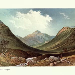
Photo Mug : 1860s Victorian Map of the Isle of Arran


![]()
Home Decor From Mary Evans Picture Library
1860s Victorian Map of the Isle of Arran
Mary Evans Picture Library makes available wonderful images created for people to enjoy over the centuries
Media ID 32350932
© The Keasbury-Gordon Photograph Archive / Mary Evans
Large Photo Mug (15 oz)
Bring a piece of history to your daily routine with our Media Storehouse Photo Mugs, featuring an exquisite 1860s Victorian Map of the Isle of Arran from The Keasbury-Gordon Photograph Archive Collection at Mary Evans Prints Online. This detailed map transports you back in time, showcasing the rich history and beauty of the Isle of Arran. Each mug is expertly crafted with high-quality materials and vibrant, long-lasting prints, ensuring your favorite historical image is displayed in stunning detail. Perfect for tea or coffee, these mugs make unique and thoughtful gifts for history enthusiasts, collectors, or anyone who appreciates the charm of the past. Embrace the nostalgia and enjoy your favorite beverage in style with our Photo Mugs.
Elevate your coffee or tea experience with our premium white ceramic mug. Its wide, comfortable handle makes drinking easy, and you can rely on it to be both microwave and dishwasher safe. Sold in single units, preview may show both sides of the same mug so you can see how the picture wraps around.
Elevate your coffee or tea experience with our premium white ceramic mug. Its wide, comfortable handle makes drinking easy, and you can rely on it to be both microwave and dishwasher safe. Sold in single units, preview may show both sides of the same mug so you can see how the picture wraps around.
These are individually made so all sizes are approximate
FEATURES IN THESE COLLECTIONS
> Europe
> United Kingdom
> Scotland
> Maps
> Europe
> United Kingdom
> Scotland
> Posters
> Europe
> United Kingdom
> Scotland
> Related Images
> Maps and Charts
> Early Maps
> Maps and Charts
> Related Images
EDITORS COMMENTS
Step back in time with this stunning 1860s Victorian map of the Isle of Arran. This vintage piece captures the intricate details and charm of a bygone era, showcasing the island's beauty and history in exquisite detail.
The map features Brodick Bay, one of Arran's most picturesque spots, as well as other landmarks that have stood the test of time. From quaint villages to rolling hills, this map offers a glimpse into what life was like on the Isle of Arran during the Victorian era.
Printed on high-quality paper, this Edwardian-era map is a true collector's item for history buffs and lovers of all things vintage. The delicate lines and elegant typography make it a beautiful addition to any home or office space.
Whether you have a connection to Scotland or simply appreciate historical artifacts, this old lantern slide will transport you back in time to an age when maps were meticulously crafted works of art. Explore every corner of Arran through this early depiction that has been preserved for generations to come.
Add a touch of nostalgia and sophistication to your decor with this 1860s Victorian Map of the Isle of Arran from The Keasbury-Gordon Photograph Archive Collection at Mary Evans Prints Online.
MADE IN THE USA
Safe Shipping with 30 Day Money Back Guarantee
FREE PERSONALISATION*
We are proud to offer a range of customisation features including Personalised Captions, Color Filters and Picture Zoom Tools
SECURE PAYMENTS
We happily accept a wide range of payment options so you can pay for the things you need in the way that is most convenient for you
* Options may vary by product and licensing agreement. Zoomed Pictures can be adjusted in the Basket.