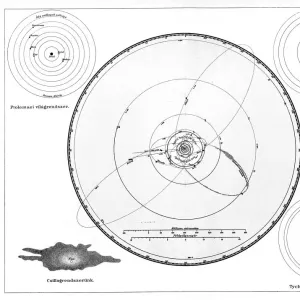
Premium Framed Print : 1873, A. and C. Black Map or Chart of the Solar System, topography, cartography, geography


![]()
Framed Photos From Liszt Collection
1873, A. and C. Black Map or Chart of the Solar System, topography, cartography, geography
1873, A. and C. Black Map or Chart of the Solar System
Liszt Collection of nineteenth-century engravings and images to browse and enjoy
Media ID 14008047
© Artokoloro Quint Lox Limited
1873 Antique Map Latitude Longitude Mappa Mundi Old Antique Plan Old Antique View Ols Antique Map Rare Old Maps Topo
14"x18" Premium Frame
Contemporary style Premium Wooden Frame with 8"x12" Print. Complete with 2" White Mat and 1.25" thick MDF frame. Printed on 260 gsm premium paper. Glazed with shatter proof UV coated acrylic glass. Backing is paper covered backing with rubber bumpers. Supplied ready to hang with a pre-installed sawtooth/wire hanger. Care Instructions: Spot clean with a damp cloth. Securely packaged in a clear plastic bag and envelope in a reinforced cardboard shipper
FSC Real Wood Frame and Double Mounted with White Conservation Mountboard - Professionally Made and Ready to Hang
Estimated Image Size (if not cropped) is 30.4cm x 20.3cm (12" x 8")
Estimated Product Size is 45.8cm x 35.6cm (18" x 14")
These are individually made so all sizes are approximate
Artwork printed orientated as per the preview above, with landscape (horizontal) orientation to match the source image.
EDITORS COMMENTS
This print showcases a remarkable piece of history - the 1873 A. and C. Black Map or Chart of the Solar System. With its intricate topography, cartography, and geography, this vintage map offers a fascinating glimpse into our understanding of the cosmos over a century ago. The detailed illustration takes us on a journey through space as we explore the various regions within our solar system. The grid lines representing latitude and longitude add a touch of geometric precision to this artistic depiction. Its aged appearance adds an air of authenticity, making it all the more appealing for collectors and enthusiasts alike. As we gaze upon this old antique view, we are transported back in time to an era when exploration and discovery were at their peak. This historical decorative piece serves as both a navigational tool and an art form, reminding us of humanity's relentless pursuit to understand our place in the universe. With its rich colors and meticulous craftsmanship, this rare old map evokes feelings of wonderment and curiosity about worlds beyond our own. It is not just paper; it represents centuries worth of knowledge passed down through generations. Whether you are an avid historian or simply appreciate beautiful artwork, this A. and C. Black Map or Chart is sure to captivate your imagination with its timeless charm.
MADE IN THE USA
Safe Shipping with 30 Day Money Back Guarantee
FREE PERSONALISATION*
We are proud to offer a range of customisation features including Personalised Captions, Color Filters and Picture Zoom Tools
SECURE PAYMENTS
We happily accept a wide range of payment options so you can pay for the things you need in the way that is most convenient for you
* Options may vary by product and licensing agreement. Zoomed Pictures can be adjusted in the Basket.