Premium Framed Print > Fine Art Storehouse > Map
Premium Framed Print : Map of Europe 1856


![]()
Framed Photos from Fine Art Storehouse
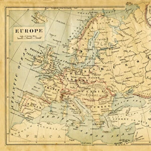
Map of Europe 1856
Colton and Fitchs Modern School Geography by George W. Fitch - New York 1856
Unleash your creativity and transform your space into a visual masterpiece!
THEPALMER
Media ID 13668793
© Roberto A Sanchez
62990 Earth Globe Man Made Object Globe Navigational Equipment Portugal World Map Obsolete Retro Styled
16"x16" Premium Frame
Contemporary style Premium Wooden Frame with 10"x10" Print. Complete with 2" White Mat and 1.25" thick MDF frame. Printed on 260 gsm premium paper. Glazed with shatter proof UV coated acrylic glass. Backing is paper covered backing with rubber bumpers. Supplied ready to hang with a pre-installed sawtooth/wire hanger. Care Instructions: Spot clean with a damp cloth. Securely packaged in a clear plastic bag and envelope in a reinforced cardboard shipper
FSC Real Wood Frame and Double Mounted with White Conservation Mountboard - Professionally Made and Ready to Hang
Estimated Image Size (if not cropped) is 25.4cm x 25.4cm (10" x 10")
Estimated Product Size is 40.6cm x 40.6cm (16" x 16")
These are individually made so all sizes are approximate
Artwork printed orientated as per the preview above, with landscape (horizontal) or portrait (vertical) orientation to match the source image.
FEATURES IN THESE COLLECTIONS
> Fine Art Storehouse
> The Magical World of Illustration
> Palmer Illustrated Collection
> Fine Art Storehouse
> Map
> Historical Maps
> Fine Art Storehouse
> Map
> Italian Maps
EDITORS COMMENTS
This print showcases a vintage "Map of Europe 1856" from the renowned Colton and Fitch's Modern School Geography by George W. Fitch, published in New York back in 1856. With its retro-styled appearance, this antique engraving takes us on a journey through time, offering a glimpse into the past when physical geography was depicted with meticulous artistry. The intricate details of this obsolete map transport us to an era where cartography was an esteemed craft. From Spain and Portugal to Italy, Germany, France, and the United Kingdom, each country is delicately outlined on this beautifully engraved image. The entire European continent unfolds before our eyes as we explore the diverse landscapes that shaped history. As we gaze upon this old-world treasure, it serves as a reminder of how far our understanding of Earth has evolved over centuries. This man-made object captures both the curiosity and ingenuity of early explorers who sought to chart unknown territories using globe navigational equipment. "The Map of Europe 1856" by THEPALMER invites us to appreciate not only its historical significance but also the artistic mastery behind its creation. Its horizontal layout allows for easy examination of every minute detail while transporting us back in time to witness Europe's geopolitical landscape during that period. With its timeless charm and educational value, this illustration is sure to captivate any admirer seeking a unique piece that combines artistry with historical relevance.
MADE IN THE USA
Safe Shipping with 30 Day Money Back Guarantee
FREE PERSONALISATION*
We are proud to offer a range of customisation features including Personalised Captions, Color Filters and Picture Zoom Tools
SECURE PAYMENTS
We happily accept a wide range of payment options so you can pay for the things you need in the way that is most convenient for you
* Options may vary by product and licensing agreement. Zoomed Pictures can be adjusted in the Cart.