Home > Maps and Charts > Early Maps
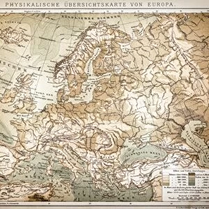
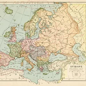
Map of Europe 1888

![]()
Wall Art and Photo Gifts from Fine Art Storehouse
Map of Europe 1888
Butlers Elementary Geography by Jacques W. Redway - Philadelphia 1888
Unleash your creativity and transform your space into a visual masterpiece!
THEPALMER
Media ID 19834473
© 2014 Roberto Adrian Photography
FEATURES IN THESE COLLECTIONS
> Europe
> Related Images
> Fine Art Storehouse
> Map
> Historical Maps
> Maps and Charts
> Early Maps
EDITORS COMMENTS
In this print titled "Map of Europe 1888" we are transported back in time to the late 19th century, where cartography was a true art form. Taken from Jacques W. Redway's renowned educational book, "Butlers Elementary Geography" published in Philadelphia in 1888, this exquisite map offers us a glimpse into the geopolitical landscape of Europe during that era. The intricate details and delicate craftsmanship showcased on this print are truly remarkable. Each country is meticulously outlined with vibrant colors, allowing us to appreciate the diversity and rich history of the European continent. From the majestic Alps cutting through central Europe to the vast expanse of Russia stretching across Eastern Europe, every geographical feature is beautifully depicted. This historical artifact not only serves as a visual representation but also provides valuable insights into how borders have shifted and nations have evolved over time. It reminds us of an era when exploration and discovery were at their peak, shaping our understanding of geography and fostering curiosity about distant lands. "The Map of Europe 1888" by THEPALMER captures both nostalgia for a bygone era and admiration for human ingenuity in mapping our world. Whether displayed as an educational tool or cherished as a piece of art, this print invites us to explore history through its intricate lines and vibrant hues – reminding us that even within static boundaries lies a dynamic story waiting to be discovered.
MADE IN THE USA
Safe Shipping with 30 Day Money Back Guarantee
FREE PERSONALISATION*
We are proud to offer a range of customisation features including Personalised Captions, Color Filters and Picture Zoom Tools
SECURE PAYMENTS
We happily accept a wide range of payment options so you can pay for the things you need in the way that is most convenient for you
* Options may vary by product and licensing agreement. Zoomed Pictures can be adjusted in the Cart.